IMAGES TAKEN NEAR TO
Lammas Field, CAMBRIDGE, CB3 9HX
Introduction
This page details the photographs taken nearby to Lammas Field, CB3 9HX by members of the Geograph project.
The Geograph project started in 2005 with the aim of publishing, organising and preserving representative images for every square kilometre of Great Britain, Ireland and the Isle of Man.

There are currently over 7.5m images from over14,400 individuals and you can help contribute to the project by visiting https://www.geograph.org.uk
Image Map
Images are licensed for reuse under creativecommons.org/licenses/by-sa/2.0
Notes
- Clicking on the map will re-center to the selected point.
- The higher the marker number, the further away the image location is from the centre of the postcode.
Image Listing (625 Images Found)
Images are licensed for reuse under creativecommons.org/licenses/by-sa/2.0
Image
Details
Distance
1
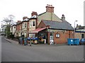
A thriving corner shop
Grantchester Street and Chedworth Street.
Image: © Mr Ignavy
Taken: 30 Oct 2008
0.02 miles
4
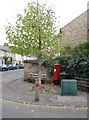
Postbox & bench
At the corner of Chedworth Street.
Image: © Mr Ignavy
Taken: 30 Oct 2008
0.03 miles
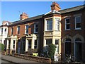
9
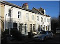
Chedworth Street
End terrace in this quiet street off Grantchester Street. Newnham Croft Primary School is at the end of the road.
Image: © Mr Ignavy
Taken: 29 Dec 2007
0.04 miles
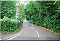
10
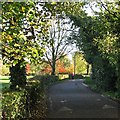
Walking past Lammas Land in November
Compare with Image], taken (also on the spur of the moment) ten months before.
Image: © John Sutton
Taken: 15 Nov 2013
0.04 miles