IMAGES TAKEN NEAR TO
Millington Lane, Millington Road, CAMBRIDGE, CB3 9HA
Introduction
This page details the photographs taken nearby to Millington Lane, Millington Road, CB3 9HA by members of the Geograph project.
The Geograph project started in 2005 with the aim of publishing, organising and preserving representative images for every square kilometre of Great Britain, Ireland and the Isle of Man.

There are currently over 7.5m images from over14,400 individuals and you can help contribute to the project by visiting https://www.geograph.org.uk
Image Map
Images are licensed for reuse under creativecommons.org/licenses/by-sa/2.0
Notes
- Clicking on the map will re-center to the selected point.
- The higher the marker number, the further away the image location is from the centre of the postcode.
Image Listing (422 Images Found)
Images are licensed for reuse under creativecommons.org/licenses/by-sa/2.0
Image
Details
Distance
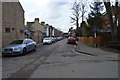
1
Newnham: up Marlowe Road
A largely Victorian part of a suburb on the south-western edge of Cambridge.
Image: © John Sutton
Taken: 19 Jul 2021
0.04 miles
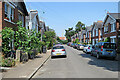
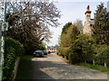
3
South Green Road: evening sunlight
An unadopted road next to St Catharine's College cricket ground.
Image: © John Sutton
Taken: 4 Jun 2012
0.05 miles
4
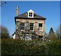
Soon to be ex-house?
Partly boarded up and with various contractors' signs outside.
Image: © Hugh Venables
Taken: 14 Feb 2009
0.05 miles
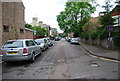
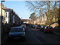
8
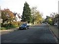
Millington Road
Looking east away from the dead end.
Image: © Mr Ignavy
Taken: 30 Oct 2008
0.06 miles
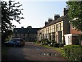
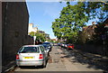
9

Newnham: building on South Green Road
A private road on the edge of Newnham, overlooking St Catharine's College cricket ground.
Image: © John Sutton
Taken: 17 Feb 2019
0.06 miles