IMAGES TAKEN NEAR TO
Haymarket Road, CAMBRIDGE, CB3 0BQ
Introduction
This page details the photographs taken nearby to Haymarket Road, CB3 0BQ by members of the Geograph project.
The Geograph project started in 2005 with the aim of publishing, organising and preserving representative images for every square kilometre of Great Britain, Ireland and the Isle of Man.

There are currently over 7.5m images from over14,400 individuals and you can help contribute to the project by visiting https://www.geograph.org.uk
Image Map
Images are licensed for reuse under creativecommons.org/licenses/by-sa/2.0
Notes
- Clicking on the map will re-center to the selected point.
- The higher the marker number, the further away the image location is from the centre of the postcode.
Image Listing (1095 Images Found)
Images are licensed for reuse under creativecommons.org/licenses/by-sa/2.0
Image
Details
Distance
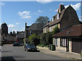
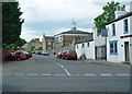
1
Honey Hill and Haymarket Road
Looking across Pound Hill on a sunny April morning.
Image: © John Sutton
Taken: 18 Apr 2015
0.01 miles
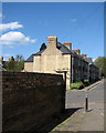
2
Pound Hill
Distinctive roofs: a house with a Mansard roof on the right and the cupolas of the United Reformed Church's Westminster College in the distance on the left.
Image: © John Sutton
Taken: 18 Apr 2015
0.02 miles
3
Up Pound Hill
Looking up hill towards Castle End Mission from near the corner of Haymarket Road. October was ending with some bright days.
Image: © John Sutton
Taken: 29 Oct 2019
0.02 miles
4
Pound Hill: extension to Castle End Mission
A corrugated-iron building attached to the south side of Castle End Mission and Working Men's Institute, looking very smart on a sunny April morning.
Image: © John Sutton
Taken: 18 Apr 2015
0.03 miles
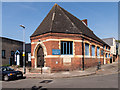
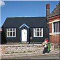
6
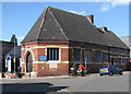
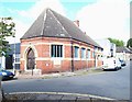
Castle End Mission and Working Men's Club
The brick mission hall on the corner of St Peter's Street and Pound Hill dates from 1884. For a closer look at the corrugated-iron extension on the left, see Image
Image: © John Sutton
Taken: 18 Apr 2015
0.04 miles
7
Pound Hill, Cambridge
As seen across Northampton Street (A1303). The building on the right is Image
Image: © Peter Church
Taken: 17 Jun 2008
0.04 miles
8
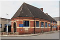
Castle End Mission
Castle End Mission and Working Men's Institute was built in 1884 to provide education for working people. At that time Castle End was a poor, very crowded and unhealthy place.
Image: © Rob Noble
Taken: 5 Apr 2013
0.04 miles
9
Albion Road and Shelly Row, Cambridge
Most recently Castle End Mission was associated with the nearby Castle Street Methodist Church, although without a formal Methodist link. Before that it was linked with the Emmanuel Congregational Church (later renamed the Trumpington Street United Reformed Church) following the appointment of an Associate Minister “with special responsibility for Castle End Mission”. Although the foundation stone for the mission church was laid by Professor James Stuart of Trinity College in 1884, from 1879 The Castle End Men’s Morning School provided a degree of education for illiterate working men from this neighbourhood. Although church services are no longer held here the premises still serves as a function venue and provides facilities for community groups. Note the corrugated extension on the left-hand side. Shelly Row lies ahead.
Image: © David Hallam-Jones
Taken: 24 Aug 2018
0.04 miles
10
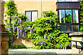
Wisteria at Honey Hill Mews
The foliage and mauve spikes soften the outline of the modern brick building.
Image: © Tiger
Taken: 14 May 2016
0.04 miles