IMAGES TAKEN NEAR TO
Trumpington Road, CAMBRIDGE, CB2 9SU
Introduction
This page details the photographs taken nearby to Trumpington Road, CB2 9SU by members of the Geograph project.
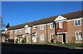
The Geograph project started in 2005 with the aim of publishing, organising and preserving representative images for every square kilometre of Great Britain, Ireland and the Isle of Man.

There are currently over 7.5m images from over14,400 individuals and you can help contribute to the project by visiting https://www.geograph.org.uk
Image Map
Images are licensed for reuse under creativecommons.org/licenses/by-sa/2.0
Notes
- Clicking on the map will re-center to the selected point.
- The higher the marker number, the further away the image location is from the centre of the postcode.
Image Listing (554 Images Found)
Images are licensed for reuse under creativecommons.org/licenses/by-sa/2.0
Image
Details
Distance
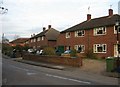
1
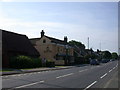
Beverley Way / Trumpington High Street (A1309)
Image: © Fernweh
Taken: 11 Aug 2021
0.00 miles
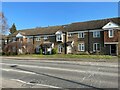
2
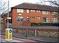
Ashcroft House
Until recently the building was occupied by Bidwells Estate Agents.
Image: © Fernweh
Taken: 11 Aug 2021
0.01 miles
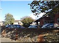
3
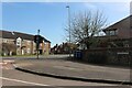
Church Lane at the junction of High Street, Trumpington
Image: © David Howard
Taken: 30 Mar 2021
0.01 miles
4
Terraced houses on High Street, Trumpington
Image: © David Howard
Taken: 27 Feb 2022
0.01 miles
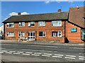
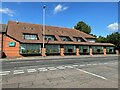
9
Bidwells office, Trumpington
Looking towards the old A10
Image: © David Howard
Taken: 5 Oct 2017
0.02 miles