IMAGES TAKEN NEAR TO
Kingfisher Gardens, CAMBRIDGE, CB2 9AP
Introduction
This page details the photographs taken nearby to Kingfisher Gardens, CB2 9AP by members of the Geograph project.
The Geograph project started in 2005 with the aim of publishing, organising and preserving representative images for every square kilometre of Great Britain, Ireland and the Isle of Man.

There are currently over 7.5m images from over14,400 individuals and you can help contribute to the project by visiting https://www.geograph.org.uk
Image Map
Images are licensed for reuse under creativecommons.org/licenses/by-sa/2.0
Notes
- Clicking on the map will re-center to the selected point.
- The higher the marker number, the further away the image location is from the centre of the postcode.
Image Listing (243 Images Found)
Images are licensed for reuse under creativecommons.org/licenses/by-sa/2.0
Image
Details
Distance
6
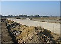
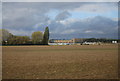
Addenbrooke's Access Road
The new road starts to take shape. This is the view from close to the point where it will cross Hobson's Brook, looking back towards the Shelford Road.
Image: © Mr Ignavy
Taken: 12 Oct 2008
0.04 miles
7
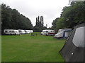
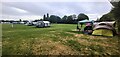
Camping & Caravan Club Campsite - Cambridge
Image: © Anthony Parkes
Taken: 14 Aug 2010
0.04 miles
8
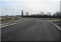
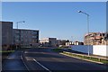
New access road for Addenbrooke's Hospital
Looking in the direction the traffic will take going to the hospital.
Image: © Mr Ignavy
Taken: 28 Dec 2008
0.05 miles
9
Cambridge Camping and Caravanning Club Site
Image: © Anthony Parkes
Taken: 13 Sep 2022
0.05 miles
10
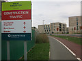
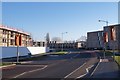
Great Kneighton construction sign
By Addenbrooke's Road.
Image: © Hugh Venables
Taken: 21 Aug 2014
0.05 miles