IMAGES TAKEN NEAR TO
Long Road, CAMBRIDGE, CB2 8HF
Introduction
This page details the photographs taken nearby to Long Road, CB2 8HF by members of the Geograph project.
The Geograph project started in 2005 with the aim of publishing, organising and preserving representative images for every square kilometre of Great Britain, Ireland and the Isle of Man.

There are currently over 7.5m images from over14,400 individuals and you can help contribute to the project by visiting https://www.geograph.org.uk
Image Map
Images are licensed for reuse under creativecommons.org/licenses/by-sa/2.0
Notes
- Clicking on the map will re-center to the selected point.
- The higher the marker number, the further away the image location is from the centre of the postcode.
Image Listing (382 Images Found)
Images are licensed for reuse under creativecommons.org/licenses/by-sa/2.0
Image
Details
Distance
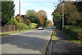
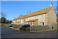
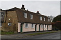
2
House & Bus stop
Long Road, western end. Close to the turning for Clay Farm.
Image: © Mr Ignavy
Taken: 25 Dec 2008
0.01 miles
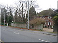
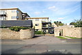
5
Hudson Close
Six houses just off Long Road.
Image: © John Sutton
Taken: 28 Nov 2017
0.04 miles
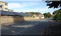
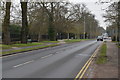
10
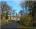
Hudson Close and the BT building
Looking towards the BT building on Long Road on a sunny morning in late November.
Image: © John Sutton
Taken: 28 Nov 2017
0.04 miles