IMAGES TAKEN NEAR TO
Setchell Drove, CAMBRIDGE, CB24 8PY
Introduction
This page details the photographs taken nearby to Setchell Drove, CB24 8PY by members of the Geograph project.
The Geograph project started in 2005 with the aim of publishing, organising and preserving representative images for every square kilometre of Great Britain, Ireland and the Isle of Man.

There are currently over 7.5m images from over14,400 individuals and you can help contribute to the project by visiting https://www.geograph.org.uk
Image Map
Images are licensed for reuse under creativecommons.org/licenses/by-sa/2.0
Notes
- Clicking on the map will re-center to the selected point.
- The higher the marker number, the further away the image location is from the centre of the postcode.
Image Listing (8 Images Found)
Images are licensed for reuse under creativecommons.org/licenses/by-sa/2.0
Image
Details
Distance
1
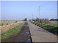
Setchell Drove
This track leads across Setchell Fen to Willow Farm, Kimpton's Farm and Taylor's Lodge near the Great Ouse
Image: © Keith Edkins
Taken: 18 Feb 2008
0.04 miles
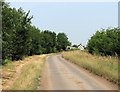
2
Setchel Drove on the hottest day of the year
Looking towards the travellers' site and Cottenham, with the bulbous pinnacles of the Jacobean church tower on the skyline to the left of centre. The temperature exceeded 30C later in the day.
Image: © John Sutton
Taken: 22 Jul 2013
0.11 miles
3
Towards Wilburton
The skyline - the low ridge on which Haddenham, Wilburton and Stretham are built - is a little less level than most in these parts.
Image: © John Sutton
Taken: 22 Jul 2013
0.13 miles
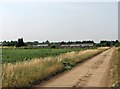
4
Towards Fenleigh Farm
A view along Lockspit Hall Drove on a hot July morning.
Image: © John Sutton
Taken: 22 Jul 2013
0.17 miles
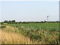
5
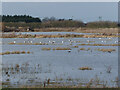
Flood on Bullocks Haste Common
This area has been flooded since last winter, creating an excellent habitat for birds. It is referred to locally as Smithey Fen by birdwatchers.
Image: © Hugh Venables
Taken: 12 Feb 2022
0.21 miles
6
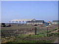
Skeletal barn on Causeway Farm
Going up or coming down? Judging by the general air of abandonment I would guess the latter.
Image: © Keith Edkins
Taken: 18 Feb 2008
0.22 miles
7
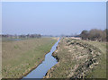
Cottenham Lode
A channel which takes water from several small streams rising north-west of Cambridge, and flows into the Great Ouse near Image
Image: © Keith Edkins
Taken: 18 Feb 2008
0.23 miles
8
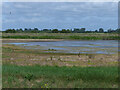
Bullocks Haste Common flood
Referred to as Smithey Fen, with water levels receding rapidly.
Image: © Hugh Venables
Taken: 19 Jun 2022
0.24 miles