IMAGES TAKEN NEAR TO
Worland Way, CAMBRIDGE, CB24 8AA
Introduction
This page details the photographs taken nearby to Worland Way, CB24 8AA by members of the Geograph project.
The Geograph project started in 2005 with the aim of publishing, organising and preserving representative images for every square kilometre of Great Britain, Ireland and the Isle of Man.

There are currently over 7.5m images from over14,400 individuals and you can help contribute to the project by visiting https://www.geograph.org.uk
Image Map
Images are licensed for reuse under creativecommons.org/licenses/by-sa/2.0
Notes
- Clicking on the map will re-center to the selected point.
- The higher the marker number, the further away the image location is from the centre of the postcode.
Image Listing (34 Images Found)
Images are licensed for reuse under creativecommons.org/licenses/by-sa/2.0
Image
Details
Distance
1

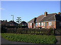
Rampton Road, Cottenham
Towards Rampton.
Image: © Robin Webster
Taken: 17 Feb 2019
0.08 miles
2
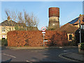
Cottenham: the corner of Rampton Road and Lambs Lane
The water tower started life as a windmill.
Image: © John Sutton
Taken: 27 Dec 2016
0.09 miles
3
House with monkey-puzzle tree, Oakington Road
Image: © Keith Edkins
Taken: 24 Jan 2008
0.09 miles
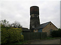
5
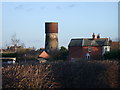
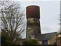
Cottenham Water Tower
Viewed from the Rampton Road
Image: © Keith Edkins
Taken: 6 Feb 2008
0.11 miles
6
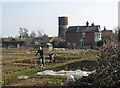
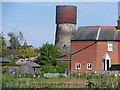
Cottenham: spring work on the allotments
The water tower in the background was originally a windmill.
Image: © John Sutton
Taken: 5 Mar 2013
0.12 miles
7
Cottenham Water Tower
Viewed from the south-east.
Image: © Peter Wood
Taken: 20 Feb 2015
0.12 miles
8
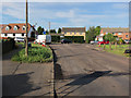
Resurfacing in Cottenham
At the junction of Oakington and Rampton Roads.
Image: © Hugh Venables
Taken: 5 Jul 2012
0.12 miles
9
Windmill turned water tower, Cottenham, Cambs
– view from Manse Drive.
Image: © Rodney Burton
Taken: 28 May 2006
0.12 miles
10
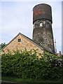
Converted water tower in Cottenham, Cambridgeshire
Brick tower mill converted to water tower with riveted steel tank. Apparently (3/05) undergoing second conversion. Mill was used for the processing of cereals from 1843 until 1898. The cap of the mill was then removed and from 1904 the building had been used as a water tower. 1903 photo is in the NMR.
Image: © Nat Bocking
Taken: Unknown
0.12 miles