IMAGES TAKEN NEAR TO
Eagle Way, CAMBRIDGE, CB24 1DL
Introduction
This page details the photographs taken nearby to Eagle Way, CB24 1DL by members of the Geograph project.
The Geograph project started in 2005 with the aim of publishing, organising and preserving representative images for every square kilometre of Great Britain, Ireland and the Isle of Man.

There are currently over 7.5m images from over14,400 individuals and you can help contribute to the project by visiting https://www.geograph.org.uk
Image Map
Images are licensed for reuse under creativecommons.org/licenses/by-sa/2.0
Notes
- Clicking on the map will re-center to the selected point.
- The higher the marker number, the further away the image location is from the centre of the postcode.
Image Listing (159 Images Found)
Images are licensed for reuse under creativecommons.org/licenses/by-sa/2.0
Image
Details
Distance
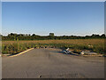
1
Turning off Eagle Way
To become Ethelred Drive.
Image: © Hugh Venables
Taken: 14 Jun 2018
0.02 miles
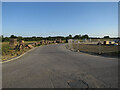
2
Taylor Wimpey car park, Northstowe
To become Canute Close.
Image: © Hugh Venables
Taken: 14 Jun 2018
0.04 miles
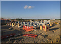
4

Taylor Wimpey compound, Northstowe
By Eagle Way.
Image: © Hugh Venables
Taken: 10 Feb 2019
0.04 miles
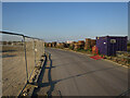
7
Construction site by Stirling Road
Linden site continuing in the first phase of the new town of Northstowe.
Image: © Hugh Venables
Taken: 14 Jun 2018
0.06 miles
8
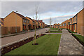
Augustus Road, Northstowe
Taylor Wimpey built houses.
Image: © Hugh Venables
Taken: 19 Jan 2021
0.07 miles
9
Turning off Stirling Road, Northstowe
To be Alfred Close.
Image: © Hugh Venables
Taken: 14 Jun 2018
0.08 miles