IMAGES TAKEN NEAR TO
The Spinney, CAMBRIDGE, CB23 8SU
Introduction
This page details the photographs taken nearby to The Spinney, CB23 8SU by members of the Geograph project.
The Geograph project started in 2005 with the aim of publishing, organising and preserving representative images for every square kilometre of Great Britain, Ireland and the Isle of Man.

There are currently over 7.5m images from over14,400 individuals and you can help contribute to the project by visiting https://www.geograph.org.uk
Image Map
Images are licensed for reuse under creativecommons.org/licenses/by-sa/2.0
Notes
- Clicking on the map will re-center to the selected point.
- The higher the marker number, the further away the image location is from the centre of the postcode.
Image Listing (38 Images Found)
Images are licensed for reuse under creativecommons.org/licenses/by-sa/2.0
Image
Details
Distance
1
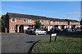
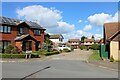
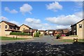
Field View, Bar Hill (2)
Field View, with houses numbered up to 104, is basically a spine road running up the hill from its junction with Crafts Way with 6 'limbs'. This shows a 'limb' at the top of the hill - it leads on to The Spinney.
Image: © Martin Tester
Taken: 12 Apr 2021
0.06 miles
2
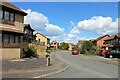
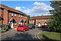
The Spinney, Bar Hill
The Spinney, from its junction with Crafts Way. The Spinney provides access to the village hall Image
Image: © Martin Tester
Taken: 11 May 2020
0.07 miles
4
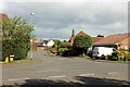
Field View, Bar Hill (3)
Field View, with houses numbered up to 104, is basically a spine road running up the hill from its junction with Crafts Way with 6 'limbs'. This shows a 'limb' at the bottom of the hill - a few yards up from the junction, for which see Image
Image: © Martin Tester
Taken: 12 Apr 2021
0.10 miles
6
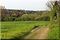
Bar Hill village from the Dry Drayton footpath
A distant view of Bar Hill village from near the top of the footpath from Dry Drayton.
Image: © Martin Tester
Taken: 11 Apr 2020
0.11 miles
7
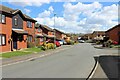
Field View, Bar Hill (1)
Field View, with houses numbered up to 104, is basically a spine road running up the hill from its junction with Crafts Way with 6 'limbs'. This shows the 'spine' from the top of the hill running down to the junction, for which see Image
Image: © Martin Tester
Taken: 12 Apr 2021
0.11 miles
8
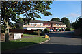
Field View & Crafts Way junction, Bar Hill
Field View, from its junction with Crafts Way
Image: © Martin Tester
Taken: 11 May 2020
0.11 miles
9
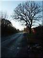
Oak Tree Bar Hill
This mature Oak tree can be found on the Bar Hill ring road.
Image: © Michael Trolove
Taken: 6 Dec 2008
0.12 miles