IMAGES TAKEN NEAR TO
Cambridge Road, CAMBRIDGE, CB23 7AU
Introduction
This page details the photographs taken nearby to Cambridge Road, CB23 7AU by members of the Geograph project.
The Geograph project started in 2005 with the aim of publishing, organising and preserving representative images for every square kilometre of Great Britain, Ireland and the Isle of Man.

There are currently over 7.5m images from over14,400 individuals and you can help contribute to the project by visiting https://www.geograph.org.uk
Image Map
Images are licensed for reuse under creativecommons.org/licenses/by-sa/2.0
Notes
- Clicking on the map will re-center to the selected point.
- The higher the marker number, the further away the image location is from the centre of the postcode.
Image Listing (65 Images Found)
Images are licensed for reuse under creativecommons.org/licenses/by-sa/2.0
Image
Details
Distance
2
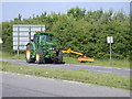
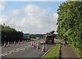
Cutting the verges on Barton Road
Mind that road sign!
Image: © Keith Edkins
Taken: 9 Jun 2008
0.04 miles
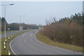
4
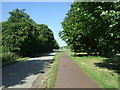
Cycle path towards Cambridge
Looking north east beside the A603.
Image: © JThomas
Taken: 10 Jun 2017
0.04 miles
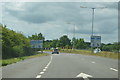
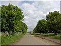
5
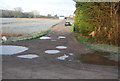
Resurfacing Barton Road
The A603, near the M11 and Grantchester and Coton junctions.
Image: © John Sutton
Taken: 27 Sep 2012
0.05 miles
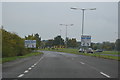
6
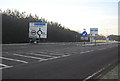
Private road to Dumpling Farm
Near junction 15 of the M11.
Image: © Steve Fareham
Taken: 7 May 2009
0.05 miles