IMAGES TAKEN NEAR TO
Cambridge Road, CAMBRIDGE, CB23 7AT
Introduction
This page details the photographs taken nearby to Cambridge Road, CB23 7AT by members of the Geograph project.
The Geograph project started in 2005 with the aim of publishing, organising and preserving representative images for every square kilometre of Great Britain, Ireland and the Isle of Man.

There are currently over 7.5m images from over14,400 individuals and you can help contribute to the project by visiting https://www.geograph.org.uk
Image Map
Images are licensed for reuse under creativecommons.org/licenses/by-sa/2.0
Notes
- Clicking on the map will re-center to the selected point.
- The higher the marker number, the further away the image location is from the centre of the postcode.
Image Listing (75 Images Found)
Images are licensed for reuse under creativecommons.org/licenses/by-sa/2.0
Image
Details
Distance
4
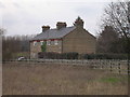
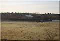
Haggis Farm Cottages, Cambridge Road
No Haggises were on view as they were all in their winter quarters
Image: © Keith Edkins
Taken: 25 Feb 2008
0.06 miles
5
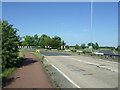
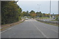
Barton Road (A603) approaching roundabout
Looking north east.
Image: © JThomas
Taken: 10 Jun 2017
0.07 miles
7
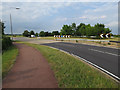
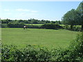
Cycle lane to Cambridge
Along the A603 from Barton.
Image: © Hugh Venables
Taken: 2 Jul 2015
0.08 miles
9
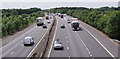
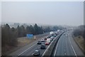
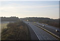
M11 motorway near Coton
Looking south from where the Grantchester-Coton road bridges the motorway, about 2 Km south of Coton, Cambridgeshire.
Image: © M H Evans
Taken: 29 Jun 2015
0.08 miles