IMAGES TAKEN NEAR TO
Dobbins Avenue, CB23 6LL
Introduction
This page details the photographs taken nearby to Dobbins Avenue, CB23 6LL by members of the Geograph project.
The Geograph project started in 2005 with the aim of publishing, organising and preserving representative images for every square kilometre of Great Britain, Ireland and the Isle of Man.

There are currently over 7.5m images from over14,400 individuals and you can help contribute to the project by visiting https://www.geograph.org.uk
Image Map
Images are licensed for reuse under creativecommons.org/licenses/by-sa/2.0
Notes
- Clicking on the map will re-center to the selected point.
- The higher the marker number, the further away the image location is from the centre of the postcode.
Image Listing (20 Images Found)
Images are licensed for reuse under creativecommons.org/licenses/by-sa/2.0
Image
Details
Distance
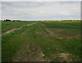
1

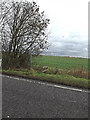
Field by A1198
Planning permission has been given for an expansion of Cambourne across this and other fields towards Caxton Gibbet.
Image: © Hugh Venables
Taken: 2 Apr 2017
0.07 miles
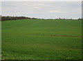
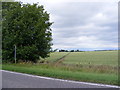
2
Fields near Cambourne
Planning permission has been given for an expansion of Cambourne across these and other fields towards Caxton Gibbet.
Image: © Hugh Venables
Taken: 2 Apr 2017
0.10 miles
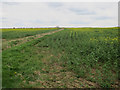
3
Crop by Caxton Gibbet
Planning permission has been given for an expansion of Cambourne across this and other fields towards Caxton Gibbet.
Image: © Hugh Venables
Taken: 2 Apr 2017
0.14 miles
4
Oilseed rape fields near Cambourne
Planning permission has been given for an expansion of Cambourne across this and other fields towards Caxton Gibbet.
Image: © Hugh Venables
Taken: 2 Apr 2017
0.15 miles
5
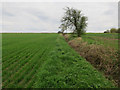
Ditch off A1198
The A1198 could be rerouted here to provide access to an expansion of Cambourne.
Image: © Hugh Venables
Taken: 2 Apr 2017
0.15 miles
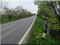
6
Footpath to Swansley Wood Farm
Off the A1198 Ermine Street
Caxton footpath no.17
Image: © Geographer
Taken: 16 Dec 2013
0.15 miles
7
Footpath to Swansley Wood Farm
Off the A1198 Ermine Street
Caxton footpath no.17
Image: © Geographer
Taken: 25 Jun 2011
0.16 miles
8
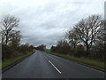
A1198 Ermine Street, Caxton
Looking towards the A428 Cambridge Road near the roundabout
Image: © Geographer
Taken: 16 Dec 2013
0.16 miles
10
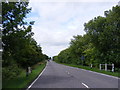
A1198 Ermine Street
Looking towards Caxton Gibbet near to footpath to Swansley Wood Farm
Image: © Geographer
Taken: 25 Jun 2011
0.17 miles