IMAGES TAKEN NEAR TO
Gladiator Road, CAMBRIDGE, CB23 6JQ
Introduction
This page details the photographs taken nearby to Gladiator Road, CB23 6JQ by members of the Geograph project.
The Geograph project started in 2005 with the aim of publishing, organising and preserving representative images for every square kilometre of Great Britain, Ireland and the Isle of Man.

There are currently over 7.5m images from over14,400 individuals and you can help contribute to the project by visiting https://www.geograph.org.uk
Image Map
Images are licensed for reuse under creativecommons.org/licenses/by-sa/2.0
Notes
- Clicking on the map will re-center to the selected point.
- The higher the marker number, the further away the image location is from the centre of the postcode.
Image Listing (15 Images Found)
Images are licensed for reuse under creativecommons.org/licenses/by-sa/2.0
Image
Details
Distance
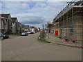
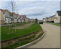
2
Upper Cambourne under construction
A continuation of the building of the new town.
Image: © Hugh Venables
Taken: 2 Apr 2017
0.12 miles
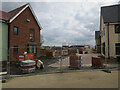
3

Construction at Cambourne
More house building, with another phase recently agreed.
Image: © Hugh Venables
Taken: 2 Apr 2017
0.13 miles
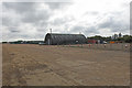
5

The entrance to Bourn Airfield
Needless to say it's no longer an airfield and will become another housing development. Presumably all the businesses using it now will have to go as well. http://www.bournairfield.co.uk/
Image: © David Howard
Taken: 12 Sep 2021
0.15 miles
6
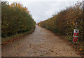
Construction haul road to Upper Cambourne
Upper Cambourne is now mostly finished, with construction activity moving to West Cambourne.
Image: © Hugh Venables
Taken: 14 Nov 2021
0.16 miles
8
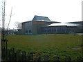
The Vine Inter-Church Primary School
The Vine is the first building in the new settlement of Upper Cambourne.
Image: © Mark Hurn
Taken: 31 Mar 2007
0.18 miles
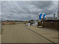
9
Bourn Airfield
The south-western end of the main runway that was.
Currently used to train motor cyclists before they hit the public roads.
Image: © Adrian S Pye
Taken: 4 Jun 2020
0.19 miles
10
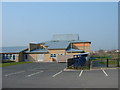
The Vine School from the East
Great Cambourne can be seen on the horizon.
Image: © Mark Hurn
Taken: 31 Mar 2007
0.19 miles