IMAGES TAKEN NEAR TO
Sheepfold Lane, CAMBRIDGE, CB23 6FR
Introduction
This page details the photographs taken nearby to Sheepfold Lane, CB23 6FR by members of the Geograph project.
The Geograph project started in 2005 with the aim of publishing, organising and preserving representative images for every square kilometre of Great Britain, Ireland and the Isle of Man.

There are currently over 7.5m images from over14,400 individuals and you can help contribute to the project by visiting https://www.geograph.org.uk
Image Map
Images are licensed for reuse under creativecommons.org/licenses/by-sa/2.0
Notes
- Clicking on the map will re-center to the selected point.
- The higher the marker number, the further away the image location is from the centre of the postcode.
Image Listing (29 Images Found)
Images are licensed for reuse under creativecommons.org/licenses/by-sa/2.0
Image
Details
Distance
1
Housing at Cherry Way, Lower Cambourne
Built by David wilson Homes as part of phase LC08.
Image: © John Brightley
Taken: 13 May 2004
0.15 miles
2
Housing courtyard at Cherry Way, Lower Cambourne
Houses built by David Wilson Homes as part of phase LC08.
Image: © John Brightley
Taken: 13 May 2004
0.16 miles
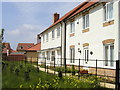
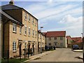
3
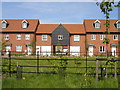
Housing at Purley Road, Lower Cambourne
Also see Image] for a view from the opposite direction. The black boarded 'barn' style buildings are annexes for the houses adjacent. Hopefully when the planting and buildings are mature the road will have the feel of a winding country lane.
Image: © John Brightley
Taken: 13 May 2004
0.17 miles
4
Housing on Merle Way, Lower Cambourne
Designed and built by Bovis Homes as part of phase LC12. Note that construction works had been completed shortly before the photograph was taken and the final road surface had still to be laid.
Image: © John Brightley
Taken: 13 May 2004
0.17 miles
5
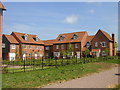
Houses at Coppice Drive, Lower Cambourne
Housing built by David Wilson Homes as part of phase LC08.
Image: © John Brightley
Taken: 13 May 2004
0.17 miles
6
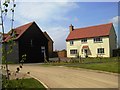
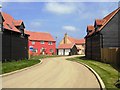
House at Purley Road, Lower Cambourne
Cambourne designers had to become increasingly inventive to ensure each area of the development has its own distinctive character, and this area, on the edge of the new village, was planned as a low density 'country lane', with large detached houses which have barn style annex buildings. These are a development of the 'flat over garage' style building first seen in phases LC01 and LC07 Image]
Image: © John Brightley
Taken: 13 May 2004
0.18 miles
7
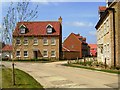
Housing at Swansley Lane, Lower Cambourne
Designed and built by Bovis Homes Central Region as part of phase LC12.
Image: © John Brightley
Taken: 13 May 2004
0.19 miles
8
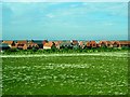
Housing in Cambourne
Cambourne is a "new village" serving the Cambridge area, and begun in the late 1990s. This picture shows houses constructed in the early 2000s.
Image: © Toby Speight
Taken: 3 Jun 2005
0.20 miles
9
Housing at Merle Way, Lower Cambourne
Built by Bovis Homes as part of phase LC12.
Image: © John Brightley
Taken: 13 May 2004
0.20 miles
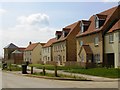
10
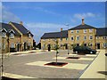
'Village square' at Merle Way, Lower Cambourne
Most unusually, this housing courtyard overlaps two build phases, which caused added complications with the construction - the details needed to match. The housing shown in the photograph is all part of Bovis Homes phase LC12, but the same paving and tree layout continues behind the photographer into Bryant Homes phase LC13. The central feature chimney of the houses in the background was a specially designed detail. It will be interesting to see how the trees mature in a few years time.
Image: © John Brightley
Taken: 13 May 2004
0.20 miles