IMAGES TAKEN NEAR TO
Vickers Way, CAMBRIDGE, CB23 6EP
Introduction
This page details the photographs taken nearby to Vickers Way, CB23 6EP by members of the Geograph project.
The Geograph project started in 2005 with the aim of publishing, organising and preserving representative images for every square kilometre of Great Britain, Ireland and the Isle of Man.

There are currently over 7.5m images from over14,400 individuals and you can help contribute to the project by visiting https://www.geograph.org.uk
Image Map
Images are licensed for reuse under creativecommons.org/licenses/by-sa/2.0
Notes
- Clicking on the map will re-center to the selected point.
- The higher the marker number, the further away the image location is from the centre of the postcode.
Image Listing (27 Images Found)
Images are licensed for reuse under creativecommons.org/licenses/by-sa/2.0
Image
Details
Distance
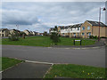
3
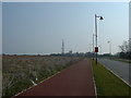
Street lights in Upper Cambourne
The street lights and cycle paths are in place awaiting the new houses in Upper Cambourne.
Image: © Mark Hurn
Taken: 31 Mar 2007
0.13 miles
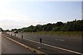
4
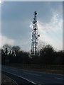
Telecoms mast and remade road to Bourn
The road has recently been made up in associated works to the A428 dualling.
Image: © Mark Hurn
Taken: 31 Mar 2007
0.13 miles
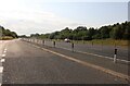
5
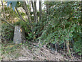
Monk Field Trig Point Flush Bracket S9369
Image: © thejackrustles
Taken: 9 Oct 2021
0.13 miles
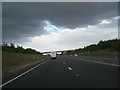
6
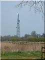
Telecoms mast
This mast dominates this grid square.
Image: © Mark Hurn
Taken: 31 Mar 2007
0.13 miles