IMAGES TAKEN NEAR TO
Battlegate Road, CAMBRIDGE, CB23 4NL
Introduction
This page details the photographs taken nearby to Battlegate Road, CB23 4NL by members of the Geograph project.
The Geograph project started in 2005 with the aim of publishing, organising and preserving representative images for every square kilometre of Great Britain, Ireland and the Isle of Man.

There are currently over 7.5m images from over14,400 individuals and you can help contribute to the project by visiting https://www.geograph.org.uk
Image Map
Images are licensed for reuse under creativecommons.org/licenses/by-sa/2.0
Notes
- Clicking on the map will re-center to the selected point.
- The higher the marker number, the further away the image location is from the centre of the postcode.
Image Listing (11 Images Found)
Images are licensed for reuse under creativecommons.org/licenses/by-sa/2.0
Image
Details
Distance
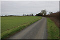
2
North on Battle Gate Road
Looking in the Boxworth direction on a bright October day.
Image: © John Sutton
Taken: 8 Oct 2015
0.08 miles
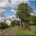
3
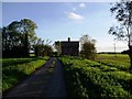
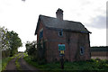
Battlegate Cottage, Boxworth
North elevation of cottage, surrounding farmland.
Image: © ethics girl
Taken: 29 Oct 2006
0.09 miles
4
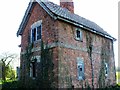
Battlegate Cottage, Boxworth
Despite its condition, this derelict cottage was full of charm and character with numerous original features, and built using local Knapwell bricks. Unfortunately, it has been demolished, and a larger, unattractive imitation put in its place.
Image: © ethics girl
Taken: 29 Oct 2006
0.10 miles
5
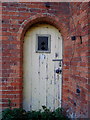
Battlegate Cottage - front door
This is a gorgeous piece of architecture - arched door and doorway (with bevelled edges on the bricks), and leaded light in the door.
Image: © ethics girl
Taken: 29 Oct 2006
0.10 miles
6
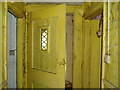
Battlegate Cottage - internal door
Original internal door with leaded light.
Image: © ethics girl
Taken: 29 Oct 2006
0.10 miles
7
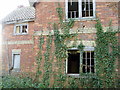
Battlegate Cottage, Boxworth
Front (east) elevation - serious structural damage, nevertheless, more sensitive renovation/re-building could have retained important architectural features.
Image: © ethics girl
Taken: 29 Oct 2006
0.10 miles
8
Derelict building at Battle Gate
This is at the end of the southern road out of Boxworth which can be driven down, but not beyond this point. The surrounding fields are on one of the highest parts of the clay 'uplands' (nearby spot height is 67m) which form the southern border of the Fens.
Image: © Sue Jones
Taken: 19 Oct 2006
0.10 miles
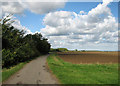
9
Bridleway at Battle Gate
A bright day in early October.
Image: © John Sutton
Taken: 8 Oct 2015
0.10 miles
10
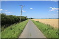
Battle Gate Road
Near Extra Farm looking in the direction of Boxworth.
Image: © Rob Noble
Taken: 22 Jul 2012
0.20 miles