IMAGES TAKEN NEAR TO
The Terrace, CAMBRIDGE, CB22 5ET
Introduction
This page details the photographs taken nearby to The Terrace, CB22 5ET by members of the Geograph project.
The Geograph project started in 2005 with the aim of publishing, organising and preserving representative images for every square kilometre of Great Britain, Ireland and the Isle of Man.

There are currently over 7.5m images from over14,400 individuals and you can help contribute to the project by visiting https://www.geograph.org.uk
Image Map
Images are licensed for reuse under creativecommons.org/licenses/by-sa/2.0
Notes
- Clicking on the map will re-center to the selected point.
- The higher the marker number, the further away the image location is from the centre of the postcode.
Image Listing (60 Images Found)
Images are licensed for reuse under creativecommons.org/licenses/by-sa/2.0
Image
Details
Distance
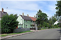
1
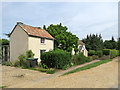
Little Shelford: cottages on The Terrace
The tarmac footpath in front of these two small cottages leads on to Whittlesford Road. Notices at each end prohibit use by bicycles and horses.
Image: © John Sutton
Taken: 23 Jul 2020
0.01 miles
2
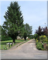
Little Shelford: The Terrace - High Street end
The tarmac footpath leads to Whittlesford Road. Notices at each end prohibit use by bicycles and horses.
Image: © John Sutton
Taken: 23 Jul 2020
0.05 miles
3
Thatched Cottage, High Street
Late C17, extended in early C18 and again C19. Restored c.1983. Timber framed, exposed, rendered infill with thatched roof of long straw. Original stack with string-course. Grade II listed. http://www.heritagegateway.org.uk/Gateway/Results_Single.aspx?resourceID=5&uid=51566
Image: © Keith Edkins
Taken: 17 Mar 2008
0.06 miles
4
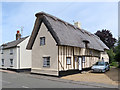
Little Shelford: thatched and timber-framed
This Grade II listed house - one of a number on High Street - was built in the late 17th century and extended in the next two centuries, In Cambridgeshire most timber-framed houses are completely plaster-rendered, but the south wall of this one has the beams exposed.
Image: © John Sutton
Taken: 23 Jul 2020
0.06 miles
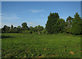
5
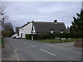
Little Shelford: on Whittlesford Road
Council-built houses near the southern end of the village.
Image: © John Sutton
Taken: 23 Jul 2020
0.06 miles
6
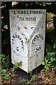
Cast Iron Milepost
Old cast iron milepost at Little Shelford, Cambridgeshire for overall view see http://www.geograph.org.uk/photo/5526097
Image: © Keith Evans
Taken: 29 Jun 2017
0.06 miles
7
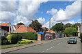
Little Shelford: a 'flagship development' and an MGB
Two large unaffordable houses are being built on High Street.
Image: © John Sutton
Taken: 1 Sep 2019
0.07 miles
9
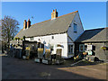
Little Shelford: The Navigator
Cask ales and Thai food are on offer.
Image: © John Sutton
Taken: 4 Dec 2017
0.07 miles
10
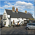
Little Shelford: The Navigator
The south-facing sign has faded to nothing. Keith Edkins' Image] shows it - a ship - in March 2008.
Image: © John Sutton
Taken: 28 Nov 2016
0.07 miles