IMAGES TAKEN NEAR TO
Stapleford, CAMBRIDGE, CB22 5ED
Introduction
This page details the photographs taken nearby to CB22 5ED by members of the Geograph project.
The Geograph project started in 2005 with the aim of publishing, organising and preserving representative images for every square kilometre of Great Britain, Ireland and the Isle of Man.

There are currently over 7.5m images from over14,400 individuals and you can help contribute to the project by visiting https://www.geograph.org.uk
Image Map
Images are licensed for reuse under creativecommons.org/licenses/by-sa/2.0
Notes
- Clicking on the map will re-center to the selected point.
- The higher the marker number, the further away the image location is from the centre of the postcode.
Image Listing (19 Images Found)
Images are licensed for reuse under creativecommons.org/licenses/by-sa/2.0
Image
Details
Distance

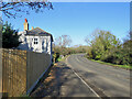
3
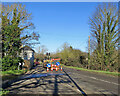
Stapleford: diversion over the bridge
The off-road path (which diverges to the left immediately after the house) keeps walkers and cyclists safely away from the blind bends over the former railway bridge, but is closed for maintenance and a temporary path over the bridge has been established. Motor traffic is controlled by temporary lights.
Image]
Image]
Image: © John Sutton
Taken: 22 Jan 2021
0.13 miles
4
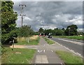
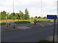
Cycle path by the A1301
Looking towards Stapleford from the junction of Cambridge Road and the Sawston bypass (behind the camera)
Image: © John Sutton
Taken: 12 Aug 2013
0.14 miles
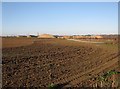
6
Stapleford: a blind bend on the A1301
This is where the road curves sharply to cross a bridge which formerly spanned the Cambridge to Colchester Stour Valley railway line, which closed in the 1960s. Fortunately for cyclists and pedestrians, there is a safe off-road cycle path which diverges immediately beyond Bridge End Cottage - see Image
Image: © John Sutton
Taken: 4 Nov 2020
0.15 miles
7
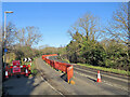
Stapleford: cycle path diversion
The off-road path (to the left) keeps walkers and cyclists safely away from the blind bends over the former railway bridge, but is closed for maintenance and a temporary path over the bridge has been established. Motor traffic is controlled by temporary lights.
Image]
Image]
Image: © John Sutton
Taken: 22 Jan 2021
0.16 miles
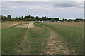
9
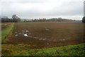
Dernford Quarry
Across fields from the cycle path beside the A1301 towards a gravel pit south of Stapleford.
Image: © John Sutton
Taken: 18 Nov 2012
0.17 miles
10
Cambridge Road junction with A1301
The sign says 'Cyclists dismount', in reality they cut the corner of the cycle path in the middle of the junction.
Image: © Hugh Venables
Taken: 8 Sep 2012
0.20 miles