IMAGES TAKEN NEAR TO
Pepperslade, CAMBRIDGE, CB22 4XT
Introduction
This page details the photographs taken nearby to Pepperslade, CB22 4XT by members of the Geograph project.
The Geograph project started in 2005 with the aim of publishing, organising and preserving representative images for every square kilometre of Great Britain, Ireland and the Isle of Man.

There are currently over 7.5m images from over14,400 individuals and you can help contribute to the project by visiting https://www.geograph.org.uk
Image Map
Images are licensed for reuse under creativecommons.org/licenses/by-sa/2.0
Notes
- Clicking on the map will re-center to the selected point.
- The higher the marker number, the further away the image location is from the centre of the postcode.
Image Listing (244 Images Found)
Images are licensed for reuse under creativecommons.org/licenses/by-sa/2.0
Image
Details
Distance
1
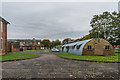
Duxford old Nissen Hut
this was probably one of the original buildings at RAF Duxford was used as the Corporals Club in 1955
Image: © Ron Gooding
Taken: 20 Oct 2004
0.02 miles
2
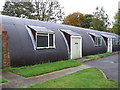
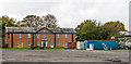
Building 285, Duxford Airfield domestic site
A Nissen Hut dating from 1941 and used as a NAAFI store.
Image: © Ian Capper
Taken: 25 Oct 2019
0.06 miles
3
Duxford old NAAFI Building
"domestic" side of the former RAF Station Duxford showing the NAAFI building constructed in 1933
Image: © Ron Gooding
Taken: 20 Oct 2004
0.08 miles
4
Hut 147, Duxford Camp
This barrack hut is the only one built during the First World War that still survives at Duxford.
Image: © David Purchase
Taken: 15 Oct 2011
0.08 miles
5
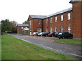
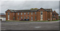
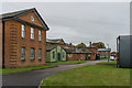
Building 8, Duxford Airfield domestic site - Airmen's Barracks
One of four identical buildings built in 1933 as airmen's barracks. The four buildings are together grade II listed - see www.historicengland.org.uk/listing/the-list/list-entry/1392875. In the foreground is the former parade ground.
Image: © Ian Capper
Taken: 25 Oct 2019
0.08 miles
6
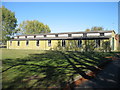
Building 215, Duxford Airfield domestic site
Built as the dining room for the site in 1939/40.
Image: © Ian Capper
Taken: 25 Oct 2019
0.08 miles
7
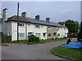
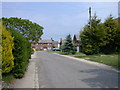
Woburn Place, Heathfield
I believe this was formerly part of Duxford Camp but has now been sold off and is a private housing estate.
Image: © Keith Edkins
Taken: 14 May 2008
0.09 miles
8
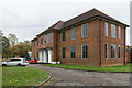
Building 6, Duxford Airfield domestic site - Institute and Dining Room
Built in 1933, the same year as the adjacent barrack blocks, to provide facilities for over 200 corporals and airmen, but extended in 1942 to cater for the far higher number of airmen and others on the site during the Second World War; the extension was later demolished. This is the front of the building facing onto the parade ground - for the rear see Image Grade II listed - see www.historicengland.org.uk/listing/the-list/list-entry/1392873.
Image: © Ian Capper
Taken: 25 Oct 2019
0.09 miles
9
Kingsway, Heathfield
Part of an estate which used to be Duxford Camp.
Image: © Keith Edkins
Taken: 14 May 2008
0.10 miles
10
Building 6, Duxford Airfield domestic site - Institute and Dining Room
Built in 1933, the same year as the adjacent barrack blocks, to provide facilities for over 200 corporals and airmen, but extended in 1942 to cater for the far higher number of airmen and others on the site during the Second World War; the extension was later demolished. This is the rear of the building - for the front facing onto the parade ground see Image Grade II listed - see www.historicengland.org.uk/listing/the-list/list-entry/1392873.
Image: © Ian Capper
Taken: 25 Oct 2019
0.10 miles