IMAGES TAKEN NEAR TO
Hill Farm Road, CAMBRIDGE, CB22 4FZ
Introduction
This page details the photographs taken nearby to Hill Farm Road, CB22 4FZ by members of the Geograph project.
The Geograph project started in 2005 with the aim of publishing, organising and preserving representative images for every square kilometre of Great Britain, Ireland and the Isle of Man.

There are currently over 7.5m images from over14,400 individuals and you can help contribute to the project by visiting https://www.geograph.org.uk
Image Map
Images are licensed for reuse under creativecommons.org/licenses/by-sa/2.0
Notes
- Clicking on the map will re-center to the selected point.
- The higher the marker number, the further away the image location is from the centre of the postcode.
Image Listing (27 Images Found)
Images are licensed for reuse under creativecommons.org/licenses/by-sa/2.0
Image
Details
Distance
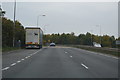
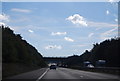
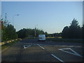
6
Lay-by on the A505
Coming up to the M11 motorway at junction 10.
Image: © Steve Fareham
Taken: 7 May 2009
0.12 miles
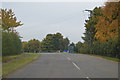
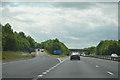
7
M11 Junction 10
The Duxford War Museum is on the other side of the roundabout.
Image: © Andrew Tatlow
Taken: 19 Sep 2012
0.12 miles
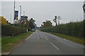
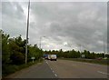
8
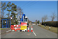
Duxford: road closed and a spelling error
Hill Farm Road was closed for the renewal of water pipes, but it was possible to cycle along the footpath at the side to the western edge of Whittlesford. Whoever made the yellow sign couldn't spell "business".
Image: © John Sutton
Taken: 8 Mar 2022
0.12 miles
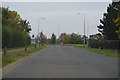
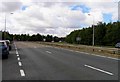
9
Roundabout on the A505 crossing the M11
Image: © David Howard
Taken: 26 Jul 2012
0.13 miles