IMAGES TAKEN NEAR TO
Maarnford Close, CAMBRIDGE, CB22 4AB
Introduction
This page details the photographs taken nearby to Maarnford Close, CB22 4AB by members of the Geograph project.
The Geograph project started in 2005 with the aim of publishing, organising and preserving representative images for every square kilometre of Great Britain, Ireland and the Isle of Man.

There are currently over 7.5m images from over14,400 individuals and you can help contribute to the project by visiting https://www.geograph.org.uk
Image Map
Images are licensed for reuse under creativecommons.org/licenses/by-sa/2.0
Notes
- Clicking on the map will re-center to the selected point.
- The higher the marker number, the further away the image location is from the centre of the postcode.
Image Listing (29 Images Found)
Images are licensed for reuse under creativecommons.org/licenses/by-sa/2.0
Image
Details
Distance
1
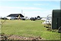
Maarnford Farm, used as a caravan store
The farm may also be a working farm but clearly this is a winter store for caravanners with small, or no, driveways
Image: © Duncan Grey
Taken: 9 Oct 2008
0.04 miles
2
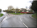
Crossroads, Duxford, Cambs
junction of Ickleton Road, Grange Road, Hunts Road and St Peter's Street.
Image: © Rodney Burton
Taken: 16 Apr 2006
0.13 miles
3
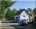
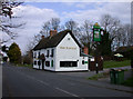
Duxford: The Plough
Other paid-up East Midlanders will doubtless be as pleased as I was to note that Everards, brewed in Leicestershire, is on sale here. The building is Grade II listed and dates from the 18th century.
Image: © John Sutton
Taken: 7 Oct 2020
0.14 miles
4
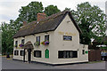
The Plough
One of three pubs in Duxford, the Plough dates from the early 18th century. Grade II listed - for listing particulars see www.historicengland.org.uk/listing/the-list/list-entry/1330937.
Image: © Ian Capper
Taken: 14 Jul 2010
0.14 miles
5
The Plough from the SW side
See description to Image
Image: © Keith Edkins
Taken: 9 Apr 2008
0.14 miles
6
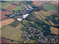
Duxford from the air
Viewed from a Stansted bound flight from Glasgow.
Image: © Thomas Nugent
Taken: 27 Sep 2016
0.15 miles
7
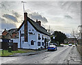
Duxford: The Plough
The 18th-century timber-framed pub on St Peter's Street is Grade II listed. The sky was clearing a little after a rainy morning in late December.
Image: © John Sutton
Taken: 30 Dec 2022
0.15 miles
8
The Plough
One of three pubs in Duxford, the Plough dates from the early 18th century. Grade II listed - for listing particulars see www.historicengland.org.uk/listing/the-list/list-entry/1330937.
Image: © Ian Capper
Taken: 14 Jul 2010
0.15 miles
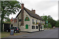
9
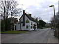
The Plough, Duxford
Early C18. Timber-framed and rendered with painted brick plinth. Ridge stack and gable end stack to left hand. Thatched roof, C20 thatched porch. Grade II listed. http://www.heritagegateway.org.uk/Gateway/Results_Single.aspx?resourceID=5&uid=52911
Image: © Keith Edkins
Taken: 9 Apr 2008
0.15 miles
10
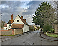
Duxford: along St Peter's Street
Looking north-east from the corner of Markby Close. The timber-framed house on the left is Grade II listed.
Image: © John Sutton
Taken: 30 Dec 2022
0.16 miles