IMAGES TAKEN NEAR TO
South Cambridge Business Park, Babraham Road, CAMBRIDGE, CB22 3JH
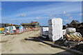
Introduction
This page details the photographs taken nearby to South Cambridge Business Park, Babraham Road, CB22 3JH by members of the Geograph project.
The Geograph project started in 2005 with the aim of publishing, organising and preserving representative images for every square kilometre of Great Britain, Ireland and the Isle of Man.

There are currently over 7.5m images from over14,400 individuals and you can help contribute to the project by visiting https://www.geograph.org.uk
Image Map
Images are licensed for reuse under creativecommons.org/licenses/by-sa/2.0
Notes
- Clicking on the map will re-center to the selected point.
- The higher the marker number, the further away the image location is from the centre of the postcode.
Image Listing (46 Images Found)
Images are licensed for reuse under creativecommons.org/licenses/by-sa/2.0
Image
Details
Distance
1

Units 14-17, South Cambridgeshire Business Park
The only company branding visible is for J F Lindsay Construction on unit 16.
Image: © Keith Edkins
Taken: 27 Mar 2008
0.02 miles
2
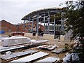
Construction on South Cambridge Business Park, Sawston
Much of this business park is already in use, but there is a fair amount of building going on as well.
Image: © David Gruar
Taken: 18 Oct 2005
0.03 miles
3
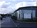
South Cambridgeshire Business Park
The main unit seen here is occupied by Wagner UK, who make fire-fighting equipment
Image: © Keith Edkins
Taken: 27 Mar 2008
0.04 miles
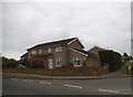
4
Sawston: building a new estate
This is a new housing estate on a wedge of land on the edge of the village, between Babraham Road and what was once the course of the Stour Valley Railway. The footpath leads to Rowley Lane, a track linking Stapleford and Babraham.
Image: © John Sutton
Taken: 28 Aug 2022
0.04 miles
5
Sawston: building The Hawthorns
When complete, this will be Webb Close, part of an estate of 95 new houses being built on the eastern edge of Sawston. The picture was taken through the site gate, a few yards north of the Babraham road, on a bright Saturday morning at the end of March.
Image: © John Sutton
Taken: 27 Mar 2021
0.05 miles
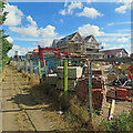
6
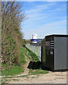
Sawston: footpath and the edge of a building site
The footpath leads to the Stapleford-Babraham bridle path. The Knights Field estate is going up on a triangular site on the road to Babraham at the eastern edge of Sawston.
Image: © John Sutton
Taken: 23 Mar 2020
0.05 miles
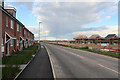
7
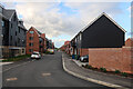
Railway Close, Sawston
New housing, over 2.5 miles from a railway station.
Image: © Hugh Venables
Taken: 13 Apr 2023
0.06 miles
8
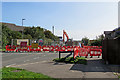
Sawston: Babraham Road closed
Sewerage works, by the look of it, for the new Knights Field housing development (see Image], taken in March 2020).
Image: © John Sutton
Taken: 18 Sep 2020
0.06 miles
9
New housing expanding Sawston
With the hedge on the right recently cut down, for no apparent reason. See Image for an earlier view
Image: © Hugh Venables
Taken: 13 Apr 2023
0.06 miles