IMAGES TAKEN NEAR TO
Common Lane, CAMBRIDGE, CB22 3HW
Introduction
This page details the photographs taken nearby to Common Lane, CB22 3HW by members of the Geograph project.
The Geograph project started in 2005 with the aim of publishing, organising and preserving representative images for every square kilometre of Great Britain, Ireland and the Isle of Man.

There are currently over 7.5m images from over14,400 individuals and you can help contribute to the project by visiting https://www.geograph.org.uk
Image Map
Images are licensed for reuse under creativecommons.org/licenses/by-sa/2.0
Notes
- Clicking on the map will re-center to the selected point.
- The higher the marker number, the further away the image location is from the centre of the postcode.
Image Listing (63 Images Found)
Images are licensed for reuse under creativecommons.org/licenses/by-sa/2.0
Image
Details
Distance
1
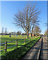
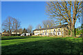
Sawston: Mill Lane Recreation Ground
Photographed on a cloudless January morning.
Image: © John Sutton
Taken: 22 Jan 2021
0.10 miles
2
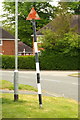
Remains of an old sign
Since Richard Haughey photographed it in 2011 Image this sign warning of "Children" has lost its panel, only the striped pole and faded red triangle sadly remaining. The companion sign at the other end of Mill Lane has also been pillaged - see Image and Image
Image: © Tiger
Taken: 9 May 2017
0.11 miles
3
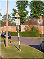
Mill Lane, Sawston
One of two pre-Worboys road signs that can be found either side of the local school. This sign is across the road from the local fire station.
Image: © Richard Haughey
Taken: 27 Apr 2011
0.11 miles
4
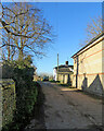
Sawston: the entrance to Huntingdon Farm
A picture taken from High Street on a cloudless January morning.
Image: © John Sutton
Taken: 22 Jan 2021
0.12 miles
6
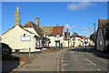
Sawston High Street on Sunday morning
The Mayflower (once The Black Bull) and The White Lion have evolved over several hundred years and are Grade II listed.
Image: © John Sutton
Taken: 5 Nov 2017
0.14 miles
7
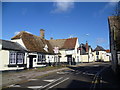
High Street, Sawston
This was once the main road through Pampisford and Sawston but it has now been by-passed to the west, which is particularly important as the road through Sawston is quite narrow with a number of bends.
Image: © Marathon
Taken: 1 Mar 2015
0.14 miles
9
Sawston: terrace on The Baulks
These houses face a green beside Mill Lane, and on the other side of it, the recreation ground.
Image: © John Sutton
Taken: 22 Jan 2021
0.15 miles
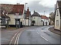
10
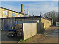
Sawston: Portobello Lane
This narrow lane off High Street (ahead to the right) serves a number of industrial and commercial concerns.
Image: © John Sutton
Taken: 10 Dec 2021
0.15 miles