IMAGES TAKEN NEAR TO
Robinson Way, CAMBRIDGE, CB2 0SZ
Introduction
This page details the photographs taken nearby to Robinson Way, CB2 0SZ by members of the Geograph project.
The Geograph project started in 2005 with the aim of publishing, organising and preserving representative images for every square kilometre of Great Britain, Ireland and the Isle of Man.

There are currently over 7.5m images from over14,400 individuals and you can help contribute to the project by visiting https://www.geograph.org.uk
Image Map
Images are licensed for reuse under creativecommons.org/licenses/by-sa/2.0
Notes
- Clicking on the map will re-center to the selected point.
- The higher the marker number, the further away the image location is from the centre of the postcode.
Image Listing (367 Images Found)
Images are licensed for reuse under creativecommons.org/licenses/by-sa/2.0
Image
Details
Distance

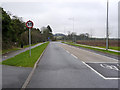
2
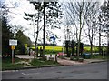
Cycleway 11 to Shelford
Leaving the grounds of Addenbrooke's Hospital (Robinson Way).
Image: © Mr Ignavy
Taken: 12 Apr 2008
0.02 miles
3
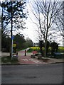
Cycleway 11
Leaving Addenbrooke's along a relatively recently redefined route.
Image: © Mr Ignavy
Taken: 12 Apr 2008
0.02 miles
5
Addenbrooke's smokers
Smoking is banned on the Addenbrooke's Hospital site, so people come to this spot on the corner of Dame Mary Archer Way for a drag. There are usually more of them than there were on this overcast Saturday afternoon.
Image: © John Sutton
Taken: 11 Mar 2017
0.03 miles
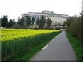
6
Dame Mary Archer Way
Part of the new network of access to Addenbrooke's from Trumpington.
Image: © Alan Murray-Rust
Taken: 27 Dec 2014
0.03 miles
7
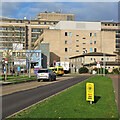
Addenbrooke's and good advice
Looking towards Addenbrooke's Hospital from the cycle path beside Dame Mary Archer Way. What a pity not all of the public health advice given during the coronavirus pandemic has been as clear and succinct as that on the yellow placard in the foreground, which reads
Be smart,
stand apart.
Respect
social distance.
Image: © John Sutton
Taken: 1 Dec 2020
0.03 miles
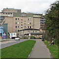
8
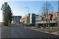
Robinson Way: new road, new lights, new car park
The shrouded traffic lights will come into use when the new road to the left, Dame Mary Archer Way, is opened. The Rosie Maternity Hospital is on the right. Work on the multi-storey car park began in summer 2013: Image
Image: © John Sutton
Taken: 1 Dec 2013
0.03 miles
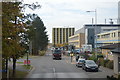
10
National Cycleway No. 11 to Shelford
This section of the route (not shown on the current OS map) heads south from Addenbrookes Hospital. A more colourful section can be seen at Image
Image: © Keith Edkins
Taken: 13 Nov 2007
0.04 miles