IMAGES TAKEN NEAR TO
Vawser Way, CAMBRIDGE, CB2 0AS
Introduction
This page details the photographs taken nearby to Vawser Way, CB2 0AS by members of the Geograph project.
The Geograph project started in 2005 with the aim of publishing, organising and preserving representative images for every square kilometre of Great Britain, Ireland and the Isle of Man.

There are currently over 7.5m images from over14,400 individuals and you can help contribute to the project by visiting https://www.geograph.org.uk
Image Map
Images are licensed for reuse under creativecommons.org/licenses/by-sa/2.0
Notes
- Clicking on the map will re-center to the selected point.
- The higher the marker number, the further away the image location is from the centre of the postcode.
Image Listing (290 Images Found)
Images are licensed for reuse under creativecommons.org/licenses/by-sa/2.0
Image
Details
Distance
1
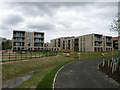
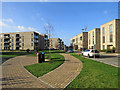
Warburton House
This H-shaped complex of 74 flats is part of the Ninewells development (formerly known as the Bell School site) and looks ready for imminent occupation. The two-bedroom apartments are dedicated to the use of the over-55s and are marketing for £345,000, with shared ownership scheme available. Social interaction is encouraged with a communal lounge, communal garden and launderette.
Image: © Keith Edkins
Taken: 2 Apr 2017
0.00 miles
2
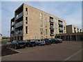
New housing - Ninewells Development
The block in the view is part of Warburton House, Vawser Way. Within the Warburton House complex are 23 two bedroom flats retirement homes with a central lounge, dining room, laundry, activities room and a hairdressing salon. Prices were in the region of £385,000 (April 2018).
Image: © Fernweh
Taken: 6 Apr 2018
0.02 miles
3
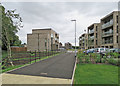
Cycle path entering Ninewells Development
Image: © Fernweh
Taken: 6 Apr 2018
0.02 miles
4
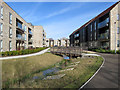
Ninewells: houses and footbridge
A completed part of the housing estate being built on Bell School land near Addenbrooke's Hospital and the Cambridge Biomedical Campus.
Image: © John Sutton
Taken: 14 Mar 2018
0.02 miles
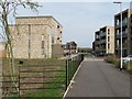
5
The Addenbrooke's end of the Ninewells development
An estate of flats and houses built on Bell School land off Babraham Road. For comparison, see Image] (November 2016).
Image: © John Sutton
Taken: 16 Jul 2017
0.02 miles
6
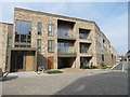
Linton House - Vawser Way
A block containing 12 two bedroom duplex apartments.
Image: © Fernweh
Taken: 6 Apr 2018
0.02 miles
7
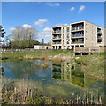
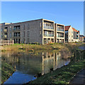
Ninewells: flats reflected
Ninewells is a recent housing estate on the southern edge of Cambridge, near Addenbrooke's Hospital (parts of which, and Car Park 2, show in the distance on the left) and the Biomedical Campus.
Image: © John Sutton
Taken: 4 Apr 2020
0.02 miles
8

Ninewells: play space on Knightly Avenue
A new housing estate on Bell School land near the hospitals and Cambridge Biomedical Campus. Addenbrooke's Hospital Car Park 2 shows in the distance to the left.
Image: © John Sutton
Taken: 23 Jul 2017
0.03 miles
9
Ninewells: green space at Vawser Way
Ninewells is a recent development on Bell School Land near to Addenbrooke's Hospital and the Cambridge Biomedical Campus.
Image: © John Sutton
Taken: 1 Feb 2020
0.03 miles
10
Ninewells: reflections in ice
Ninewells is a recently-built estate on the south side of Cambridge, near the Biomedical Campus. After a cold night there was still a thin skin of ice on this pond late in the morning of a cloudless day.
Image] (March 2018) is a comparable view.
Image: © John Sutton
Taken: 20 Jan 2020
0.03 miles