IMAGES TAKEN NEAR TO
Queen Ediths Way, CAMBRIDGE, CB1 8NW
Introduction
This page details the photographs taken nearby to Queen Ediths Way, CB1 8NW by members of the Geograph project.
The Geograph project started in 2005 with the aim of publishing, organising and preserving representative images for every square kilometre of Great Britain, Ireland and the Isle of Man.

There are currently over 7.5m images from over14,400 individuals and you can help contribute to the project by visiting https://www.geograph.org.uk
Image Map (Loading...)


Getting Data...Please wait
Leaflet Map data © OpenStreetMap
Images are licensed for reuse under creativecommons.org/licenses/by-sa/2.0
Notes
- Clicking on the map will re-center to the selected point.
- The higher the marker number, the further away the image location is from the centre of the postcode.
Image Listing (94 Images Found)
Images are licensed for reuse under creativecommons.org/licenses/by-sa/2.0
Image
Details
Distance
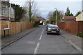

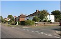
3

Strangeways Road
Looking down the slope from the Queen Edith's Way end on a Sunday afternoon in early March.
Image: © John Sutton
Taken: 5 Mar 2017
0.06 miles
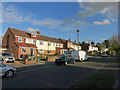
4
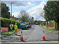
Beaumont Road closed
New tarmac in the southern suburbs of Cambridge.
Image: © John Sutton
Taken: 12 Apr 2021
0.06 miles
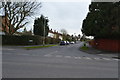
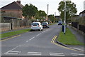
6
On Strangeways Road
In the southern suburbs of Cambridge on a drab Sunday afternoon in May.
Image: © John Sutton
Taken: 10 May 2020
0.07 miles
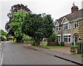
7
Queen Edith's Way at the junction of Chalk Grove
Image: © David Howard
Taken: 9 Aug 2020
0.08 miles
10
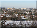
Prospect of Cambridge from Limekiln Hill
The Netherhall School playing fields and the houses of Beaumont Road are in the foreground. Prominent on the horizon, left to right, are The Belvedere, the brick tower of the University Library, the white Spiller's building near the railway station, and behind it the spire of the Catholic church.
Image: © John Sutton
Taken: 20 Dec 2009
0.09 miles