IMAGES TAKEN NEAR TO
Walpole Road, CAMBRIDGE, CB1 3UE
Introduction
This page details the photographs taken nearby to Walpole Road, CB1 3UE by members of the Geograph project.
The Geograph project started in 2005 with the aim of publishing, organising and preserving representative images for every square kilometre of Great Britain, Ireland and the Isle of Man.

There are currently over 7.5m images from over14,400 individuals and you can help contribute to the project by visiting https://www.geograph.org.uk
Image Map (Loading...)


Getting Data...Please wait
Leaflet Map data © OpenStreetMap
Images are licensed for reuse under creativecommons.org/licenses/by-sa/2.0
Notes
- Clicking on the map will re-center to the selected point.
- The higher the marker number, the further away the image location is from the centre of the postcode.
Image Listing (48 Images Found)
Images are licensed for reuse under creativecommons.org/licenses/by-sa/2.0
Image
Details
Distance
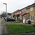
1
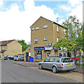
Williams Stores, Walpole Road
May Bank Holiday Monday in the Cambridge suburbs.
Image: © John Sutton
Taken: 1 May 2017
0.02 miles
2
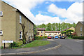
Walpole Road
Suburban Cambridge on May Bank Holiday Monday.
Image: © John Sutton
Taken: 1 May 2017
0.03 miles
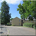
3

Along St Bede's Crescent
The eastern suburbs of Cambridge in early September.
Image: © John Sutton
Taken: 4 Sep 2019
0.05 miles
4
Sunflowers on St Bede's Crescent
Late summer in the Cambridge suburbs.
Image: © John Sutton
Taken: 4 Sep 2019
0.06 miles
5
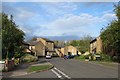
The corner of Walpole Road and Birdwood Road
Looking towards the St Bede's Crescent estate, most of which is in the next gridsquare to the east, Image Birdwood Road is to the left, the Daws Lane path to the right.
Image: © John Sutton
Taken: 23 Oct 2014
0.06 miles
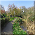
6
Cycle route along brook
There is a very small playground serving the housing estate on the left: just the slide and a set of swings on the side of the road.
Image: © Colin Bell
Taken: 1 Apr 2008
0.08 miles
7
Snakey Path near St Bede's Gardens
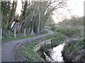
Snakey Path runs beside Cherry Hinton Brook from Doggett Road to Burnside and the east end of Mill Road. The brook rises from the chalk at Giant's Grave and, as Coldham's Brook, reaches the River Cam at Stourbridge Common.
Image: © John Sutton
Taken: 30 Mar 2019
0.09 miles
8
St Bede's Gardens
A grey and chilly January morning in the southern suburbs of Cambridge.
Image: © John Sutton
Taken: 14 Jan 2020
0.09 miles
9
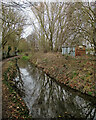
Snakey Path, the brook and a railway relic
Snakey Path runs beside Cherry Hinton Brook to Brookfields (ahead). On the right is a railway relic to lift the spirits on a drab winter morning: enthusiasts will already have identified the rusty pressed-steel end as that of a British Railways 12T Goods Van of a type first built over seventy years ago. Its wooden sides have been faced with corrugated iron.
Image: © John Sutton
Taken: 19 Feb 2021
0.09 miles
10
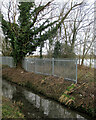
New security fencing by Cherry Hinton Brook
Taken from Snakey Path, near St Bede's Gardens. There is a glimpse through the trees of the flooded chalk pit at the former cement works, which closed in 1984.
Image: © John Sutton
Taken: 19 Feb 2021
0.09 miles