IMAGES TAKEN NEAR TO
Cyprus Road, CAMBRIDGE, CB1 3QA
Introduction
This page details the photographs taken nearby to Cyprus Road, CB1 3QA by members of the Geograph project.
The Geograph project started in 2005 with the aim of publishing, organising and preserving representative images for every square kilometre of Great Britain, Ireland and the Isle of Man.

There are currently over 7.5m images from over14,400 individuals and you can help contribute to the project by visiting https://www.geograph.org.uk
Image Map
Images are licensed for reuse under creativecommons.org/licenses/by-sa/2.0
Notes
- Clicking on the map will re-center to the selected point.
- The higher the marker number, the further away the image location is from the centre of the postcode.
Image Listing (350 Images Found)
Images are licensed for reuse under creativecommons.org/licenses/by-sa/2.0
Image
Details
Distance
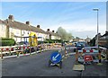
1
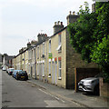
Up Cyprus Road
A typical Cambridge terrace.
Image: © John Sutton
Taken: 4 Aug 2019
0.01 miles
4
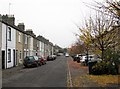
Malta Road in November
A typical Victorian terrace on the left and a modern one on the right, built on what used to be the playground of Romsey Primary School.
Image: © John Sutton
Taken: 15 Nov 2012
0.04 miles
5
New pipes in Suez Road
Looking towards Mill Road on a spring morning.
Image: © John Sutton
Taken: 9 Apr 2014
0.04 miles
6

Along Suez Road
Looking towards Mill Road on an October afternoon. Bins and parked cars narrow the pavements.
Image: © John Sutton
Taken: 11 Oct 2017
0.04 miles