IMAGES TAKEN NEAR TO
Rustat Avenue, CAMBRIDGE, CB1 3PG
Introduction
This page details the photographs taken nearby to Rustat Avenue, CB1 3PG by members of the Geograph project.
The Geograph project started in 2005 with the aim of publishing, organising and preserving representative images for every square kilometre of Great Britain, Ireland and the Isle of Man.

There are currently over 7.5m images from over14,400 individuals and you can help contribute to the project by visiting https://www.geograph.org.uk
Image Map
Images are licensed for reuse under creativecommons.org/licenses/by-sa/2.0
Notes
- Clicking on the map will re-center to the selected point.
- The higher the marker number, the further away the image location is from the centre of the postcode.
Image Listing (1451 Images Found)
Images are licensed for reuse under creativecommons.org/licenses/by-sa/2.0
Image
Details
Distance
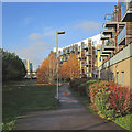
1
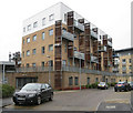
New homes for Cambridge
Rustat Avenue - probably priced at a premium given their closeness to the railway station as well as the town centre.
Image: © Mr Ignavy
Taken: 21 Feb 2010
0.01 miles
3
The Gallery: south-facing balconies
Flats on the former Leica site between the railway and Rustat Road, photographed on a sunny early-autumn afternoon.
Image: © John Sutton
Taken: 2 Oct 2014
0.02 miles
4
Rustat Avenue: south-facing balconies
There had been a sprinkling of snow - the first of the 2017-18 winter - the previous evening.
Image: © John Sutton
Taken: 1 Dec 2017
0.02 miles
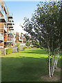
5
Rustat Avenue: balconies and birch leaves
A brief bright spell on a November morning. Image] was taken in December 2018, before the building on the left, on Station Road, was finished.
Image: © John Sutton
Taken: 22 Nov 2019
0.02 miles
6
Rustat Avenue flats
The cranes on the skyline on the left are working on a site at the corner of Station Road and Station Place, on the other side of the railway. Image] is a comparable picture taken in 2019.
Image: © John Sutton
Taken: 30 Sep 2021
0.02 miles
7
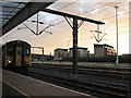
The Gallery, from Platform 4
The three blocks of flats, The Gallery, are on the Leica site on Rustat Road, just south of the Carter Cycle Bridge.
Image: © John Sutton
Taken: 23 Sep 2009
0.02 miles
8
Biodiversity Improvement Project
A nearby notice explains that Cambridge City Council is "committed to to enhancing our parks and open spaces for wildlife ... We have removed sections of turf to reduce competition from the existing low number of vigorous grass species, which will allow a more diverse range of flowering species to flourish, providing food and cover for a wider range of insects. This in turn will increase the diversity and abundance of food for birds and bats that use the green network of our parks, surrounding gardens and green spaces."
The flats to the right are on Rustat Avenue.
Image: © John Sutton
Taken: 1 May 2024
0.02 miles
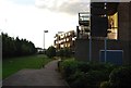
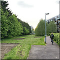
9

Rustat Avenue
A development on the Leica site, photographed on a cloudy Sunday morning.
Image: © John Sutton
Taken: 29 Jun 2014
0.02 miles
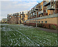
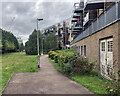
10
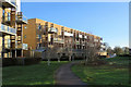
Flats on Rustat Avenue in winter
South-facing balconies overlook a narrow green space.
Image: © John Sutton
Taken: 17 Dec 2018
0.03 miles