IMAGES TAKEN NEAR TO
Occupation Road, CAMBRIDGE, CB1 2QR
Introduction
This page details the photographs taken nearby to Occupation Road, CB1 2QR by members of the Geograph project.
The Geograph project started in 2005 with the aim of publishing, organising and preserving representative images for every square kilometre of Great Britain, Ireland and the Isle of Man.

There are currently over 7.5m images from over14,400 individuals and you can help contribute to the project by visiting https://www.geograph.org.uk
Image Map
Images are licensed for reuse under creativecommons.org/licenses/by-sa/2.0
Notes
- Clicking on the map will re-center to the selected point.
- The higher the marker number, the further away the image location is from the centre of the postcode.
Image Listing (1003 Images Found)
Images are licensed for reuse under creativecommons.org/licenses/by-sa/2.0
Image
Details
Distance
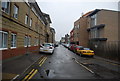
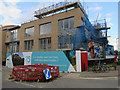
1
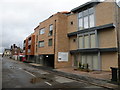
Cuprum, Occupation Road
New residential block just coming onto the market. Prices for a 2-bedroom flat, sorry, apartment, are around a quarter of a million.
Image: © Keith Edkins
Taken: 25 Dec 2012
0.01 miles
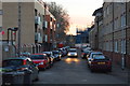
3
New housing, Occupation Road
Fourteen new apartments. See Image
Image: © Hugh Venables
Taken: 22 Jul 2015
0.01 miles
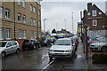
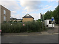
4
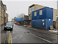
New Housing, Occupation Road
On the site of New Street Garage.
Image: © Hugh Venables
Taken: 12 Feb 2012
0.02 miles