IMAGES TAKEN NEAR TO
Broad Street, CAMBRIDGE, CB1 2NJ
Introduction
This page details the photographs taken nearby to Broad Street, CB1 2NJ by members of the Geograph project.
The Geograph project started in 2005 with the aim of publishing, organising and preserving representative images for every square kilometre of Great Britain, Ireland and the Isle of Man.

There are currently over 7.5m images from over14,400 individuals and you can help contribute to the project by visiting https://www.geograph.org.uk
Image Map (Loading...)


Getting Data...Please wait
Leaflet Map data © OpenStreetMap
Images are licensed for reuse under creativecommons.org/licenses/by-sa/2.0
Notes
- Clicking on the map will re-center to the selected point.
- The higher the marker number, the further away the image location is from the centre of the postcode.
Image Listing (1110 Images Found)
Images are licensed for reuse under creativecommons.org/licenses/by-sa/2.0
Image
Details
Distance
1
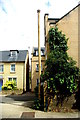
Stinkpipe 66 in Broad Street
At the dead end of Broad Street near the modern entrance to the Flower Street Estate stands this well-preserved if slightly shabby stench pole, complete with its decorative base and corona cap. I couldn't find a maker's name but it looks like a typical example of the work of Ham, Baker - ostensibly Engineers of Westminster though their works were at Tipton in the Black Country - who supplied many such products to grace the streets of Cambridge and other cities.
Map of Cambridge Stinkpipes https://www.google.com/maps/d/viewer?mid=1tGa-vqWr8XI064h9UKIdCi-HU70&ll=52.21302083594113%2C0.12626532754352215&z=18
Stinkpipes and Sewers of Cambridge
Image: © Tiger
Taken: 18 Jul 2020
0.02 miles
2
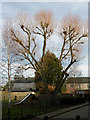
Flower Street play area
Dominated by that strange sort of tree you get a couple of years after vigorous pollarding.
Image: © Keith Edkins
Taken: 28 Jan 2010
0.02 miles
3
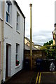
Stinkpipe (66a*) in Norfolk Terrace
Outside no 63, at the northern end of the western arm of this street, this stench pole still has its corona cap but has lost the usual ornate base (if it ever had one).
*It is not recorded on the 2013 map but I have given it a conjectural number based on its nearest neighbour Image which is just the other side of the modern housing in the Flower Street Estate, seen behind the brick wall.
Stinkpipes and Sewers of Cambridge https://www.google.com/maps/d/viewer?mid=1tGa-vqWr8XI064h9UKIdCi-HU70&ll=52.20093555963426%2C0.1343196499999877&z=14
Update: by the beginning of February 2021 this pipe has been removed Image
Image: © Tiger
Taken: 18 Jul 2020
0.02 miles
4
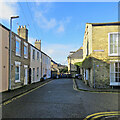
Norfolk Terrace and the corner of Blossom Street
The sewer stink pipe outside the last house on the left, photographed as recently as July 2020 (Image]), has been removed.
Image: © John Sutton
Taken: 5 Feb 2021
0.02 miles
5

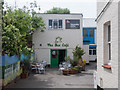
Broad Street, Cambridge
A play area 2-3 minutes away from Anglia Ruskin University.
Image: © David Hallam-Jones
Taken: 27 Aug 2018
0.03 miles
6

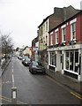
Blossom Street on a February morning
Looking from the Norfolk Terrace end towards The Blue Moon on Norfolk Street.
Image: © John Sutton
Taken: 5 Feb 2021
0.04 miles
8
Norfolk Street
The cafes do well being so close to Anglia Ruskin University.
Image: © Mr Ignavy
Taken: 23 Dec 2008
0.05 miles
9

Cook For You, Norfolk Street
This Chinese Takeaway and Chip Shop is recently under new management, with a new name (formerly New Times), and a new colour scheme
Image: © Keith Edkins
Taken: 27 Jan 2008
0.05 miles
10

Cook For You, Norfolk Street
This has been a Chinese Take-away for many years but is now changing to a Caribbean Cuisine to be called B's Kitchen
Image: © Keith Edkins
Taken: 6 Jun 2015
0.05 miles