IMAGES TAKEN NEAR TO
Malcolm Place, CAMBRIDGE, CB1 1LS
Introduction
This page details the photographs taken nearby to Malcolm Place, CB1 1LS by members of the Geograph project.
The Geograph project started in 2005 with the aim of publishing, organising and preserving representative images for every square kilometre of Great Britain, Ireland and the Isle of Man.

There are currently over 7.5m images from over14,400 individuals and you can help contribute to the project by visiting https://www.geograph.org.uk
Image Map
Images are licensed for reuse under creativecommons.org/licenses/by-sa/2.0
Notes
- Clicking on the map will re-center to the selected point.
- The higher the marker number, the further away the image location is from the centre of the postcode.
Image Listing (4304 Images Found)
Images are licensed for reuse under creativecommons.org/licenses/by-sa/2.0
Image
Details
Distance
3
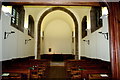
Chapel of Westcott House
The barrel-vaulted chapel, along with the rest of the cloistered south range of the college, was designed by the architect Morley Horder. A Latin inscription at the entrance dates it to 1926. For the view looking west, see Image
As the college website states: "Its uncluttered simplicity makes it an ideal space for the range of services that happen there" http://www.westcott.cam.ac.uk/chapel/ .
Image: © Tiger
Taken: 30 Sep 2017
0.02 miles
4
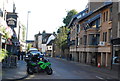
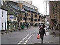
King Street: coffee on the corner
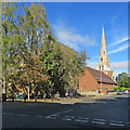
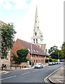
Customers of The Locker Café (behind the camera) were enjoying autumn sunshine in its seating area on the corner of Manor Street. The Grade I listed All Saints' Church, on Jesus Lane, dates from the 1860s and was then the tallest building in Cambridge.
Image: © John Sutton
Taken: 13 Oct 2021
0.02 miles
5
Manor Street, Cambridge
A view of the Grade 1-listed All Saints' Church. Apparently it has not been used for regular worship since 1973 and its ownership and management were vested in The Churches Conservation Trust in 1981. The church was built between 1863-70, in English Gothic Revival style, the architect being George Frederick Bodley. The tower and spire, modelled on St Oswald's Church, Ashbourne, Derbyshire, were added between 1869-71. The church’s overall height is said to be 175 feet (53 m), making it the city’s third tallest building. The building is used during term time by Westcott House, an adjacent theological college (one of its student "Halls" appear on the left), and in addition, it's available as a function venue too. Each Monday-Saturday it is open to visitors, many of whom come to see its Arts and Crafts style fittings. Jesus Lane and Jesus College are situated ahead.
Image: © David Hallam-Jones
Taken: 27 Aug 2018
0.02 miles
6
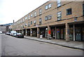
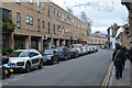
December in King Street
The modern shops in the centre back on to Christ's College New Court.
Image: © John Sutton
Taken: 7 Dec 2012
0.02 miles
8
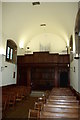
Chapel of Westcott House
Looking towards the organ gallery, the simple chapel was designed by Morley Horder in 1926. For the view looking east, see Image
Image: © Tiger
Taken: 30 Sep 2017
0.02 miles
9
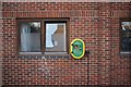
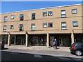
Defibrillator
On the wall of the apartments in Image is a public defibrillator
Image: © Bob Harvey
Taken: 24 Oct 2018
0.02 miles