IMAGES TAKEN NEAR TO
Strethall, SAFFRON WALDEN, CB11 4XL
Introduction
This page details the photographs taken nearby to CB11 4XL by members of the Geograph project.
The Geograph project started in 2005 with the aim of publishing, organising and preserving representative images for every square kilometre of Great Britain, Ireland and the Isle of Man.

There are currently over 7.5m images from over14,400 individuals and you can help contribute to the project by visiting https://www.geograph.org.uk
Image Map
Images are licensed for reuse under creativecommons.org/licenses/by-sa/2.0
Notes
- Clicking on the map will re-center to the selected point.
- The higher the marker number, the further away the image location is from the centre of the postcode.
Image Listing (7 Images Found)
Images are licensed for reuse under creativecommons.org/licenses/by-sa/2.0
Image
Details
Distance
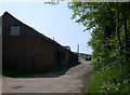
3
Royston Road
Royston Road looking north east near to Strethall, Essex.
Image: © Keith Evans
Taken: 3 May 2016
0.20 miles
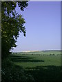
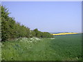
4
Field track at Poplar Farm
A farm track at Poplar Farm. Argers Plantation on the horizon
Image: © Steve F
Taken: 20 Oct 2002
0.21 miles
5
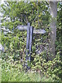
Bridleway and Public Footpath signs
A more rustic feel to these Essex signs than the green and white reflective signs I'm used to in Cambridgeshire.
Image: © Keith Edkins
Taken: 7 May 2008
0.22 miles
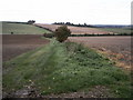
6
Hedgerow and footpath
This public footpath doesn't go anywhere much - it stops at the Cambridgeshire boundary in the next square to the north
Image: © Keith Edkins
Taken: 7 May 2008
0.22 miles
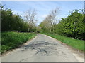
7
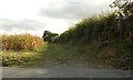
Bridleway by Royston Lane
This is the start of the bridleway at Royston Lane, which leads down to Strethall Church.
Image: © Robert Edwards
Taken: 12 Oct 2009
0.24 miles