IMAGES TAKEN NEAR TO
Duddenhoe End, SAFFRON WALDEN, CB11 4UX
Introduction
This page details the photographs taken nearby to CB11 4UX by members of the Geograph project.
The Geograph project started in 2005 with the aim of publishing, organising and preserving representative images for every square kilometre of Great Britain, Ireland and the Isle of Man.

There are currently over 7.5m images from over14,400 individuals and you can help contribute to the project by visiting https://www.geograph.org.uk
Image Map (Loading...)


Getting Data...Please wait
Leaflet Map data © OpenStreetMap
Images are licensed for reuse under creativecommons.org/licenses/by-sa/2.0
Notes
- Clicking on the map will re-center to the selected point.
- The higher the marker number, the further away the image location is from the centre of the postcode.
Image Listing (6 Images Found)
Images are licensed for reuse under creativecommons.org/licenses/by-sa/2.0
Image
Details
Distance
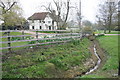
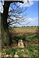
2
Footpath And Sign
Concrete footpath sign and footpath near to Bridge Green, Essex.
Image: © Keith Evans
Taken: 4 Jul 2017
0.03 miles
4
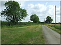
Beards Lane
Beards Lane looking north east near to Duddenhoe End, Essex.
Image: © Keith Evans
Taken: 4 Jul 2017
0.11 miles
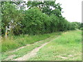
6
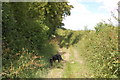
Lorking's Lane
South of Duddenhoe End.
Image: © Trevor Harris
Taken: 2 Jul 2014
0.25 miles