IMAGES TAKEN NEAR TO
West End, SAFFRON WALDEN, CB11 4UJ
Introduction
This page details the photographs taken nearby to West End, CB11 4UJ by members of the Geograph project.
The Geograph project started in 2005 with the aim of publishing, organising and preserving representative images for every square kilometre of Great Britain, Ireland and the Isle of Man.

There are currently over 7.5m images from over14,400 individuals and you can help contribute to the project by visiting https://www.geograph.org.uk
Image Map (Loading...)


Getting Data...Please wait
Leaflet Map data © OpenStreetMap
Images are licensed for reuse under creativecommons.org/licenses/by-sa/2.0
Notes
- Clicking on the map will re-center to the selected point.
- The higher the marker number, the further away the image location is from the centre of the postcode.
Image Listing (9 Images Found)
Images are licensed for reuse under creativecommons.org/licenses/by-sa/2.0
Image
Details
Distance
2
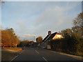
Royston Road, Wendens Ambo
The little window on the house has been added since 2011
Image: © David Howard
Taken: 28 Oct 2017
0.10 miles

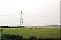
4
Farm track west of Wendens Ambo (2)
Hosting a public footpath. The M11 is visible on the horizon.
Image: © Richard Vince
Taken: 12 Mar 2022
0.17 miles
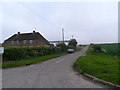
6
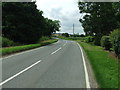
Royston Road
Royston Road looking west near to Wendens Ambo. Essex.
Image: © Keith Evans
Taken: 28 Jun 2016
0.21 miles
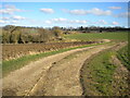
7
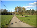
Farm track west of Wendens Ambo (1)
Hosting a public footpath.
Image: © Richard Vince
Taken: 12 Mar 2022
0.22 miles
9
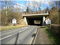
Tunnel under M11, Wendens Ambo
Allowing Royston Road to enter the village from the west.
Image: © Richard Vince
Taken: 12 Mar 2022
0.25 miles