IMAGES TAKEN NEAR TO
Butts Green, SAFFRON WALDEN, CB11 4RT
Introduction
This page details the photographs taken nearby to Butts Green, CB11 4RT by members of the Geograph project.
The Geograph project started in 2005 with the aim of publishing, organising and preserving representative images for every square kilometre of Great Britain, Ireland and the Isle of Man.

There are currently over 7.5m images from over14,400 individuals and you can help contribute to the project by visiting https://www.geograph.org.uk
Image Map (Loading...)


Getting Data...Please wait
Leaflet Map data © OpenStreetMap
Images are licensed for reuse under creativecommons.org/licenses/by-sa/2.0
Notes
- Clicking on the map will re-center to the selected point.
- The higher the marker number, the further away the image location is from the centre of the postcode.
Image Listing (7 Images Found)
Images are licensed for reuse under creativecommons.org/licenses/by-sa/2.0
Image
Details
Distance
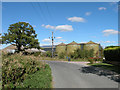
1
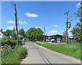
Brices Yard, Butts Green
Farm buildings occupied by a number of businesses.
Image: © John Sutton
Taken: 26 May 2023
0.10 miles
2
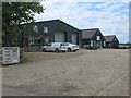
Brices Yard, Butts Green
Four industrial units.
Image: © Hugh Venables
Taken: 7 Jul 2014
0.10 miles
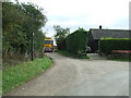
3
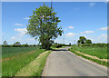
On the way to Langley
This is Valance Road, which links Clavering and Langley Upper Green (ahead).
Image: © John Sutton
Taken: 26 May 2023
0.17 miles
4
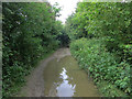
Byway from Butts Green
As it joins the route of a Roman Road.
Image: © Hugh Venables
Taken: 7 Jul 2014
0.22 miles
6
Footpath Off Minor Road
Footpath off minor road at Butts Green, Essex.
Image: © Keith Evans
Taken: 9 Oct 2017
0.23 miles
7
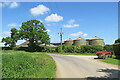
Barns and silos at Thurrocks Farm
Between Langley Upper Green (left) and Clavering.
Image: © John Sutton
Taken: 26 May 2023
0.23 miles