IMAGES TAKEN NEAR TO
Audley End, SAFFRON WALDEN, CB11 4JJ
Introduction
This page details the photographs taken nearby to CB11 4JJ by members of the Geograph project.
The Geograph project started in 2005 with the aim of publishing, organising and preserving representative images for every square kilometre of Great Britain, Ireland and the Isle of Man.

There are currently over 7.5m images from over14,400 individuals and you can help contribute to the project by visiting https://www.geograph.org.uk
Image Map (Loading...)


Getting Data...Please wait
Leaflet Map data © OpenStreetMap
Images are licensed for reuse under creativecommons.org/licenses/by-sa/2.0
Notes
- Clicking on the map will re-center to the selected point.
- The higher the marker number, the further away the image location is from the centre of the postcode.
Image Listing (17 Images Found)
Images are licensed for reuse under creativecommons.org/licenses/by-sa/2.0
Image
Details
Distance
1
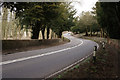
London Road
The B1383 (formerly A11), north of Wendens Ambo, near to Brand's Hill.
Image: © Peter Trimming
Taken: 1 Apr 2015
0.03 miles
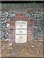
2

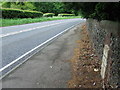
Boundary Marker on London Road
Benchmark (arrow on hidden face), marking the junction of the Borough of Walden with the Parish of Littlebury.
Image: © Peter Trimming
Taken: 1 Apr 2015
0.03 miles
3
Old Milepost
Old milepost near to Wendens, Essex on what was the old A.11. For close up view see http://www.geograph.org.uk/photo/1304722 for info on the post see http://milestones.megalithia.com/sites/tl519373.htm do look at their home page.
Image: © Keith Evans
Taken: 15 May 2009
0.04 miles
4

Boundary Marker on London Road
Benchmark, marking the junction of the Borough of Walden with the Parish of Littlebury.
Image: © Peter Trimming
Taken: 1 Apr 2015
0.04 miles
5
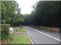
London Road (B1383) towards Littlebury
Looking north east.
Image: © JThomas
Taken: 2 Sep 2017
0.05 miles
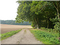
6
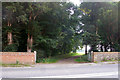
Entrance to Wilkinson's Meadow, Audley End
The track continues to other parts of the Audley End estate.
Image: © Robin Webster
Taken: 3 Oct 2015
0.06 miles
7
Old Milestone
Old milepost near to Wendens Ambo, Essex on part of what was the A.11. For overall view see http://www.geograph.org.uk/photo/1304717 For more info see http://milestones.megalithia.com/sites/tl519373.htm do look at their home page.
Image: © Keith Evans
Taken: 15 May 2009
0.07 miles
8
Estate track, Audley End
West of London Road.
Image: © Robin Webster
Taken: 3 Oct 2015
0.07 miles
9

Wall Beside London Road
On the B1383 (formerly A11) close to London Lodge, on Brand's Hill.
Image: © Peter Trimming
Taken: 1 Apr 2015
0.08 miles
10
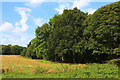
Field off London Road
View west from London Road.
Image: © Wayland Smith
Taken: 18 Sep 2021
0.08 miles