IMAGES TAKEN NEAR TO
Wood Hall, SAFFRON WALDEN, CB11 4HA
Introduction
This page details the photographs taken nearby to Wood Hall, CB11 4HA by members of the Geograph project.
The Geograph project started in 2005 with the aim of publishing, organising and preserving representative images for every square kilometre of Great Britain, Ireland and the Isle of Man.

There are currently over 7.5m images from over14,400 individuals and you can help contribute to the project by visiting https://www.geograph.org.uk
Image Map
Images are licensed for reuse under creativecommons.org/licenses/by-sa/2.0
Notes
- Clicking on the map will re-center to the selected point.
- The higher the marker number, the further away the image location is from the centre of the postcode.
Image Listing (16 Images Found)
Images are licensed for reuse under creativecommons.org/licenses/by-sa/2.0
Image
Details
Distance
2
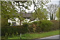
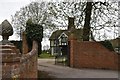
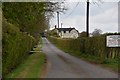
The lodge at Wood Hall, near Arkesden, Essex
The road is Clatterbury Lane.
Image: © Robert Edwards
Taken: 27 Oct 2006
0.16 miles
6
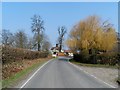
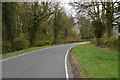
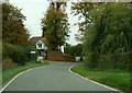
Clatterbury Lane, Arkesden
I don't know what kind of tree that is on the right, but it provides some colour before the other trees have got their leaves.
Image: © Bikeboy
Taken: 10 Apr 2013
0.19 miles