IMAGES TAKEN NEAR TO
Haynes Road, SAFFRON WALDEN, CB11 4FB
Introduction
This page details the photographs taken nearby to Haynes Road, CB11 4FB by members of the Geograph project.
The Geograph project started in 2005 with the aim of publishing, organising and preserving representative images for every square kilometre of Great Britain, Ireland and the Isle of Man.

There are currently over 7.5m images from over14,400 individuals and you can help contribute to the project by visiting https://www.geograph.org.uk
Image Map (Loading...)


Getting Data...Please wait
Leaflet Map data © OpenStreetMap
Images are licensed for reuse under creativecommons.org/licenses/by-sa/2.0
Notes
- Clicking on the map will re-center to the selected point.
- The higher the marker number, the further away the image location is from the centre of the postcode.
Image Listing (11 Images Found)
Images are licensed for reuse under creativecommons.org/licenses/by-sa/2.0
Image
Details
Distance
1
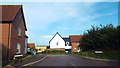
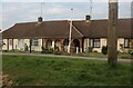
Oxleys Close, Clavering
Oxleys Close is a development of new housing in the village of Clavering, Essex.
Image: © Malc McDonald
Taken: 3 Aug 2013
0.08 miles
7
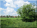
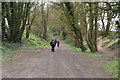
Clavering: towards Stortford Road
A view from the track south from the village.
Image: © John Sutton
Taken: 1 Jun 2014
0.22 miles
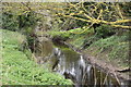
8
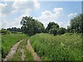
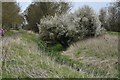
South from Clavering
A track beside the bank of the infant River Stort (lost amid the cow parsley to the right).
Image: © John Sutton
Taken: 1 Jun 2014
0.23 miles