IMAGES TAKEN NEAR TO
Cambridge Road, SAFFRON WALDEN, CB11 3YN
Introduction
This page details the photographs taken nearby to Cambridge Road, CB11 3YN by members of the Geograph project.
The Geograph project started in 2005 with the aim of publishing, organising and preserving representative images for every square kilometre of Great Britain, Ireland and the Isle of Man.

There are currently over 7.5m images from over14,400 individuals and you can help contribute to the project by visiting https://www.geograph.org.uk
Image Map (Loading...)


Getting Data...Please wait
Leaflet Map data © OpenStreetMap
Images are licensed for reuse under creativecommons.org/licenses/by-sa/2.0
Notes
- Clicking on the map will re-center to the selected point.
- The higher the marker number, the further away the image location is from the centre of the postcode.
Image Listing (3 Images Found)
Images are licensed for reuse under creativecommons.org/licenses/by-sa/2.0
Image
Details
Distance
1
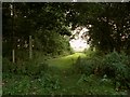
A public footpath, viewed from Belcham's Lane
Image: © Robert Edwards
Taken: 15 Aug 2008
0.14 miles
2
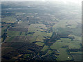
Rickling Green from the air
Stansted Airport is visible to the top left.
Image: © Thomas Nugent
Taken: 7 Feb 2014
0.19 miles
3
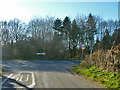
Junction on B1383
The lane through Patmore End meets what used to be the A11.
Image: © Robin Webster
Taken: 16 Mar 2014
0.25 miles