IMAGES TAKEN NEAR TO
Church End, SAFFRON WALDEN, CB11 3YL
Introduction
This page details the photographs taken nearby to Church End, CB11 3YL by members of the Geograph project.
The Geograph project started in 2005 with the aim of publishing, organising and preserving representative images for every square kilometre of Great Britain, Ireland and the Isle of Man.

There are currently over 7.5m images from over14,400 individuals and you can help contribute to the project by visiting https://www.geograph.org.uk
Image Map (Loading...)


Getting Data...Please wait
Leaflet Map data © OpenStreetMap
Images are licensed for reuse under creativecommons.org/licenses/by-sa/2.0
Notes
- Clicking on the map will re-center to the selected point.
- The higher the marker number, the further away the image location is from the centre of the postcode.
Image Listing (65 Images Found)
Images are licensed for reuse under creativecommons.org/licenses/by-sa/2.0
Image
Details
Distance
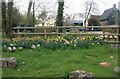
2
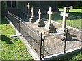
Judd family grave stones, Rickling Parish Church
Image: © David Beresford
Taken: 5 Sep 2013
0.00 miles
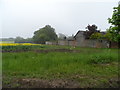
3
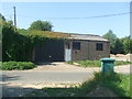
Farm building, Rickling
This building stands across a lane from the old vicarage at Rickling.
Image: © David Beresford
Taken: 5 Sep 2013
0.05 miles
5
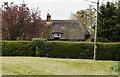
Woodnook
Grade II listed. https://historicengland.org.uk/listing/the-list/list-entry/1275768
Image: © N Chadwick
Taken: 14 Apr 2019
0.05 miles
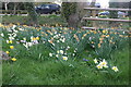
7
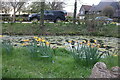
Pretty garden on Brick Kiln Lane, Rickling
Image: © David Howard
Taken: 3 Apr 2022
0.06 miles
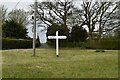
10
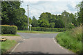
Junction with Rickling Road
Left for Wickham Bonhunt, straight on to Rickling.
Image: © J.Hannan-Briggs
Taken: 7 Jul 2014
0.06 miles