IMAGES TAKEN NEAR TO
Brick Kiln Lane, SAFFRON WALDEN, CB11 3YH
Introduction
This page details the photographs taken nearby to Brick Kiln Lane, CB11 3YH by members of the Geograph project.
The Geograph project started in 2005 with the aim of publishing, organising and preserving representative images for every square kilometre of Great Britain, Ireland and the Isle of Man.

There are currently over 7.5m images from over14,400 individuals and you can help contribute to the project by visiting https://www.geograph.org.uk
Image Map (Loading...)


Getting Data...Please wait
Leaflet Map data © OpenStreetMap
Images are licensed for reuse under creativecommons.org/licenses/by-sa/2.0
Notes
- Clicking on the map will re-center to the selected point.
- The higher the marker number, the further away the image location is from the centre of the postcode.
Image Listing (5 Images Found)
Images are licensed for reuse under creativecommons.org/licenses/by-sa/2.0
Image
Details
Distance
1
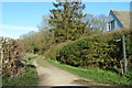
Bridleway off Brick Kiln Lane
Used by the Harcamlow Way trail.
Image: © Robin Webster
Taken: 16 Mar 2014
0.13 miles

3
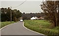
Approach to Rickling Green from Rickling
Image: © Robert Edwards
Taken: 23 Oct 2006
0.17 miles
4
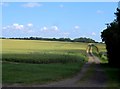
Track through wheat field near Rickling Green
Marked as a right of way (footpath) on the O.S. map.
Image: © Bikeboy
Taken: 21 Jun 2014
0.18 miles
5
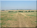
Footpath from Coney Acre Wood
This view is from the edge of the wood looking north west with the footpath leading to Rickling.
Image: © David Beresford
Taken: 5 Sep 2013
0.20 miles