IMAGES TAKEN NEAR TO
CB11 3XS
Introduction
This page details the photographs taken nearby to CB11 3XS by members of the Geograph project.
The Geograph project started in 2005 with the aim of publishing, organising and preserving representative images for every square kilometre of Great Britain, Ireland and the Isle of Man.

There are currently over 7.5m images from over14,400 individuals and you can help contribute to the project by visiting https://www.geograph.org.uk
Image Map
Images are licensed for reuse under creativecommons.org/licenses/by-sa/2.0
Notes
- Clicking on the map will re-center to the selected point.
- The higher the marker number, the further away the image location is from the centre of the postcode.
Image Listing (7 Images Found)
Images are licensed for reuse under creativecommons.org/licenses/by-sa/2.0
Image
Details
Distance
1
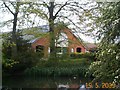
Little Henham Hall farm
The old cattle barn seen from across the duck pond.
Image: © Mark Camp
Taken: 19 May 2005
0.06 miles
3
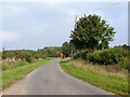
Lane, Little Henham
Between Little Henham Hall and Jock Farm.
Image: © Robin Webster
Taken: 3 Oct 2015
0.15 miles
4
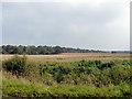
Farmland and woods east of Little Henham Hall
Image: © Robin Webster
Taken: 3 Oct 2015
0.16 miles
5
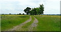
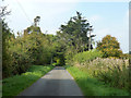
Track and public footpath south from Little Henham
The footpath comes out at Image
Image: © Jonathan Billinger
Taken: 20 Jun 2008
0.22 miles
6
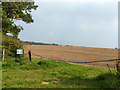
Footpath only
So says the sign. The right of way runs up the left margin of the field through Prior's Wood to Widdington.
Image: © Robin Webster
Taken: 3 Oct 2015
0.23 miles
7
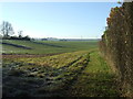
Looking West
Footpath looking west near to Widdington, Essex.
Image: © Keith Evans
Taken: 29 Nov 2016
0.25 miles