IMAGES TAKEN NEAR TO
Wicken Road, SAFFRON WALDEN, CB11 3UN
Introduction
This page details the photographs taken nearby to Wicken Road, CB11 3UN by members of the Geograph project.
The Geograph project started in 2005 with the aim of publishing, organising and preserving representative images for every square kilometre of Great Britain, Ireland and the Isle of Man.

There are currently over 7.5m images from over14,400 individuals and you can help contribute to the project by visiting https://www.geograph.org.uk
Image Map
Images are licensed for reuse under creativecommons.org/licenses/by-sa/2.0
Notes
- Clicking on the map will re-center to the selected point.
- The higher the marker number, the further away the image location is from the centre of the postcode.
Image Listing (2 Images Found)
Images are licensed for reuse under creativecommons.org/licenses/by-sa/2.0
Image
Details
Distance
1
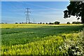
Farmland and pylons south of the B1038
Image: © Philip Jeffrey
Taken: 21 May 2023
0.09 miles
2
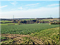
View NNW from Rickling Road
A little of Wicken Bonhunt may be seen in the valley.
Image: © Robin Webster
Taken: 16 Mar 2014
0.24 miles