IMAGES TAKEN NEAR TO
Bury Water Lane, SAFFRON WALDEN, CB11 3UB
Introduction
This page details the photographs taken nearby to Bury Water Lane, CB11 3UB by members of the Geograph project.
The Geograph project started in 2005 with the aim of publishing, organising and preserving representative images for every square kilometre of Great Britain, Ireland and the Isle of Man.

There are currently over 7.5m images from over14,400 individuals and you can help contribute to the project by visiting https://www.geograph.org.uk
Image Map (Loading...)


Getting Data...Please wait
Leaflet Map data © OpenStreetMap
Images are licensed for reuse under creativecommons.org/licenses/by-sa/2.0
Notes
- Clicking on the map will re-center to the selected point.
- The higher the marker number, the further away the image location is from the centre of the postcode.
Image Listing (33 Images Found)
Images are licensed for reuse under creativecommons.org/licenses/by-sa/2.0
Image
Details
Distance
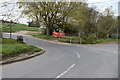
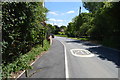
2
Whiteditch Lane, Bury Water Lane junction
Image: © N Chadwick
Taken: 10 Jun 2017
0.05 miles
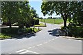
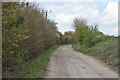
3
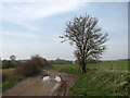
Newport: Bury Water Lane
A bridle way which runs over the hills west of Newport.
Image: © John Sutton
Taken: 29 Mar 2014
0.05 miles
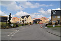
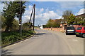
6
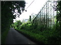
Disused Greenhouses
Former greenhouses in Whiteditch Lane, Newport, Essex. The site of the glass houses is not earmarked for a small housing estate.
Image: © Keith Evans
Taken: 28 Jun 2016
0.07 miles
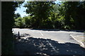
8
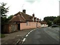
Old cottages at Newport, Essex
The road in the photo is Bury Water Lane.
Image: © Robert Edwards
Taken: 21 Aug 2006
0.09 miles