IMAGES TAKEN NEAR TO
Sparrows End, SAFFRON WALDEN, CB11 3TU
Introduction
This page details the photographs taken nearby to Sparrows End, CB11 3TU by members of the Geograph project.
The Geograph project started in 2005 with the aim of publishing, organising and preserving representative images for every square kilometre of Great Britain, Ireland and the Isle of Man.

There are currently over 7.5m images from over14,400 individuals and you can help contribute to the project by visiting https://www.geograph.org.uk
Image Map
Images are licensed for reuse under creativecommons.org/licenses/by-sa/2.0
Notes
- Clicking on the map will re-center to the selected point.
- The higher the marker number, the further away the image location is from the centre of the postcode.
Image Listing (12 Images Found)
Images are licensed for reuse under creativecommons.org/licenses/by-sa/2.0
Image
Details
Distance
1
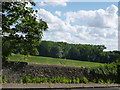
Flint wall on Sparrowsend Hill near Audley End
Image: © Richard Humphrey
Taken: 17 Jul 2016
0.07 miles
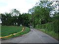
2
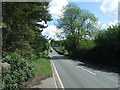
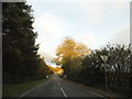
Sparrowsend Hill (B1052)
Looking north east, Shortgrove Bridge.
Image: © JThomas
Taken: 20 May 2017
0.10 miles
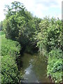
3
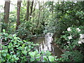
River Cam at Shortgrove Bridge
The river Cam (or Granta) winding through the trees at Shortgrove Bridge, between Wendens Ambo and Saffron Walden
Image: © Steve F
Taken: 29 May 2007
0.10 miles
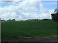
4
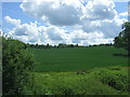
Crop field, Wendens Ambo
View from Shortgrove Bridge
Image: © JThomas
Taken: 20 May 2017
0.12 miles
6
River Cam at Shortgrove Bridge
Looking south.
Image: © JThomas
Taken: 20 May 2017
0.15 miles
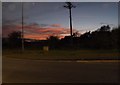
10
Rookery Lane, Wendens Ambo
Looking west towards the level crossing on the London Liverpool Street - Cambridge line.
Image: © JThomas
Taken: 20 May 2017
0.22 miles