IMAGES TAKEN NEAR TO
Mole Hall, SAFFRON WALDEN, CB11 3SS
Introduction
This page details the photographs taken nearby to Mole Hall, CB11 3SS by members of the Geograph project.
The Geograph project started in 2005 with the aim of publishing, organising and preserving representative images for every square kilometre of Great Britain, Ireland and the Isle of Man.

There are currently over 7.5m images from over14,400 individuals and you can help contribute to the project by visiting https://www.geograph.org.uk
Image Map (Loading...)


Getting Data...Please wait
Leaflet Map data © OpenStreetMap
Images are licensed for reuse under creativecommons.org/licenses/by-sa/2.0
Notes
- Clicking on the map will re-center to the selected point.
- The higher the marker number, the further away the image location is from the centre of the postcode.
Image Listing (19 Images Found)
Images are licensed for reuse under creativecommons.org/licenses/by-sa/2.0
Image
Details
Distance
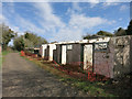
2
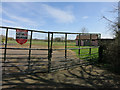
Mole Hall Wildlife Park, closed
The car park and toilet block of the closed wildlife and butterfly park.
Image: © Hugh Venables
Taken: 12 Apr 2015
0.10 miles
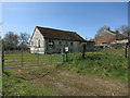
3
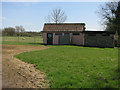
Closed toilet block
By the car park of the former Mole Hall Wildlife Park.
Image: © Hugh Venables
Taken: 12 Apr 2015
0.12 miles
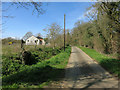
5
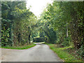
Cornells Lane, Widdington
A dead-end as a surfaced road, but it continues as a rather rough byway.
Image: © Robin Webster
Taken: 3 Oct 2015
0.13 miles
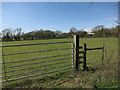
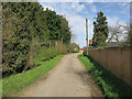
8
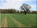
Footpath to Mole Hall
Following tractor tramlines as a best option. The tree is probably the last remnant of an old field boundary that the footpath used to follow.
Image: © Hugh Venables
Taken: 12 Apr 2015
0.16 miles