IMAGES TAKEN NEAR TO
Purton End, SAFFRON WALDEN, CB11 3JT
Introduction
This page details the photographs taken nearby to Purton End, CB11 3JT by members of the Geograph project.
The Geograph project started in 2005 with the aim of publishing, organising and preserving representative images for every square kilometre of Great Britain, Ireland and the Isle of Man.

There are currently over 7.5m images from over14,400 individuals and you can help contribute to the project by visiting https://www.geograph.org.uk
Image Map
Images are licensed for reuse under creativecommons.org/licenses/by-sa/2.0
Notes
- Clicking on the map will re-center to the selected point.
- The higher the marker number, the further away the image location is from the centre of the postcode.
Image Listing (11 Images Found)
Images are licensed for reuse under creativecommons.org/licenses/by-sa/2.0
Image
Details
Distance
1
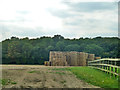
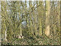
Straw stack near Debden
Beyond is Howe Wood.
Image: © Robin Webster
Taken: 27 Sep 2014
0.07 miles
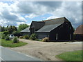
2
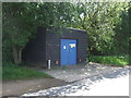
Building on Debden Road, Purton End
Purpose unknown.
Image: © JThomas
Taken: 20 May 2017
0.09 miles
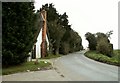
6
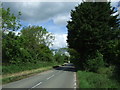
Debden Road, Purton End
Looking north west.
Image: © JThomas
Taken: 20 May 2017
0.15 miles
7
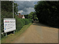
Pamphillions Farm entrance
With a sign for a few industrial units.
Image: © Hugh Venables
Taken: 7 Jul 2014
0.19 miles
8
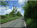
Debden Road near Newhouse Farm
Looking north west.
Image: © JThomas
Taken: 20 May 2017
0.19 miles
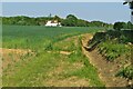
10
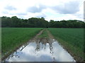
Waterlogged and muddy bridleway
Heavy going towards Howe Wood - looking south.
Image: © JThomas
Taken: 20 May 2017
0.22 miles