IMAGES TAKEN NEAR TO
Audley Road, SAFFRON WALDEN, CB11 3HW
Introduction
This page details the photographs taken nearby to Audley Road, CB11 3HW by members of the Geograph project.
The Geograph project started in 2005 with the aim of publishing, organising and preserving representative images for every square kilometre of Great Britain, Ireland and the Isle of Man.

There are currently over 7.5m images from over14,400 individuals and you can help contribute to the project by visiting https://www.geograph.org.uk
Image Map
Images are licensed for reuse under creativecommons.org/licenses/by-sa/2.0
Notes
- Clicking on the map will re-center to the selected point.
- The higher the marker number, the further away the image location is from the centre of the postcode.
Image Listing (302 Images Found)
Images are licensed for reuse under creativecommons.org/licenses/by-sa/2.0
Image
Details
Distance
1
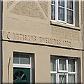
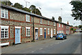
Saffron Walden: Artisans Dwellings
These distinctive plastered terraces, built in 1882, face each other across a passage. For a close-up, see Image
Image: © John Sutton
Taken: 17 Mar 2016
0.03 miles
2
Saffron Walden: Tanners Way and the rear of Artisans Dwellings
Houses on New Road are in the background. For the fronts of the Artisans Dwellings terraces, see Image
Image: © John Sutton
Taken: 17 Mar 2016
0.03 miles
3
Saffron Walden: detail of 1 Artisans Dwellings
Simple pargetting on the terrace shown in Image
Image: © John Sutton
Taken: 17 Mar 2016
0.04 miles
4
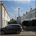
Houses on East Street, Saffron Walden
This is on the central one way system.
Image: © David Howard
Taken: 3 Apr 2022
0.07 miles
5
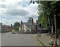
B1053 junction south of The Maze
The picture is taken from Radwinter Road looking up Audley Road with East Street curving away to the right.
Image: © Stuart Logan
Taken: 28 Jun 2013
0.07 miles
6
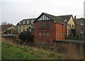
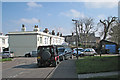
Buildings by The Common
To me they look like old industrial premises.
Image: © Mr Ignavy
Taken: 20 Feb 2009
0.07 miles
7
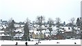
Snow and fun on The Common
The snow on the 2nd February, 2009 closed the schools and turned The Common into a winter play area.
Image: © Alan Hawkes
Taken: 2 Feb 2009
0.07 miles
8
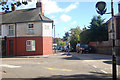
Corner of Audley Road and Fairycroft road
Image: © John Firth
Taken: 15 Sep 2010
0.08 miles
9
31 to 41 (odds) East Street, Saffron Walden
Part of a longer row starting at 17.
Image: © Robin Webster
Taken: 27 Sep 2014
0.08 miles
10
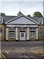
Boys' British School, East Street, Saffron Walden
Seen from New Street. The date 1838 is inscribed on the side of the pediment. It appears that the building is no longer a school, currently being used as offices by the Independent Schools Association and various other businesses. The building is listed, Grade II: http://www.britishlistedbuildings.co.uk/en-370523-boys-british-school-saffron-walden-essex
The first 'British Schools' were set up in the early 19th century by a non-denominational charity - 'The British and Foreign School Society for the Education of the Labouring and Manufacturing Classes of Society of Every Religious Persuasion'. They were quite distinct from (and in a sense rivals of) the 'National Schools', which had similar charitable purposes, but were Church of England foundations. http://en.wikipedia.org/wiki/British_and_Foreign_School_Society
Image: © Stefan Czapski
Taken: 30 Jun 2013
0.08 miles